TheLastGentleman wrote: ↑Wed Feb 26, 2020 3:01 pm
Also, here's the west alternative, for comparison.
After further review, It looks to me as though central alignment will actually take out more buildings than the west one.
Is there any talk of BNSF build a rail bridge? I would think that this would be a great opportunity for them to improve their situation. It always seems like trains have to travel slowly over the current bridge
normalthings wrote: ↑Thu Feb 27, 2020 12:42 am
Is there any talk of BNSF build a rail bridge? I would think that this would be a great opportunity for them to improve their situation. It always seems like trains have to travel slowly over the current bridge
Travel between two rail yards should be slow. It's not like the trains are all immediately leaving town.
moderne wrote: ↑Wed Feb 26, 2020 2:28 pm
I don't know if I am looking at it correctly, but it looks like northbound 35 at the NW corner of the bluffs has the right lane as the through lane and the 6th St/Broadway exit on the left?
If I'm looking at it right then technically that left lane is still the thru-lane, since in addition to the 6th-street exit it also has the lane that continues on as I-35.
You are correct. I was only seeing it as the 6th St exit. I wonder what the traffic count is comparing traffic coming around that bend going to the river crossing or continuing onto 35 east.
moderne wrote: ↑Thu Feb 27, 2020 12:33 pm
You are correct. I was only seeing it as the 6th St exit. I wonder what the traffic count is comparing traffic coming around that bend going to the river crossing or continuing onto 35 east.
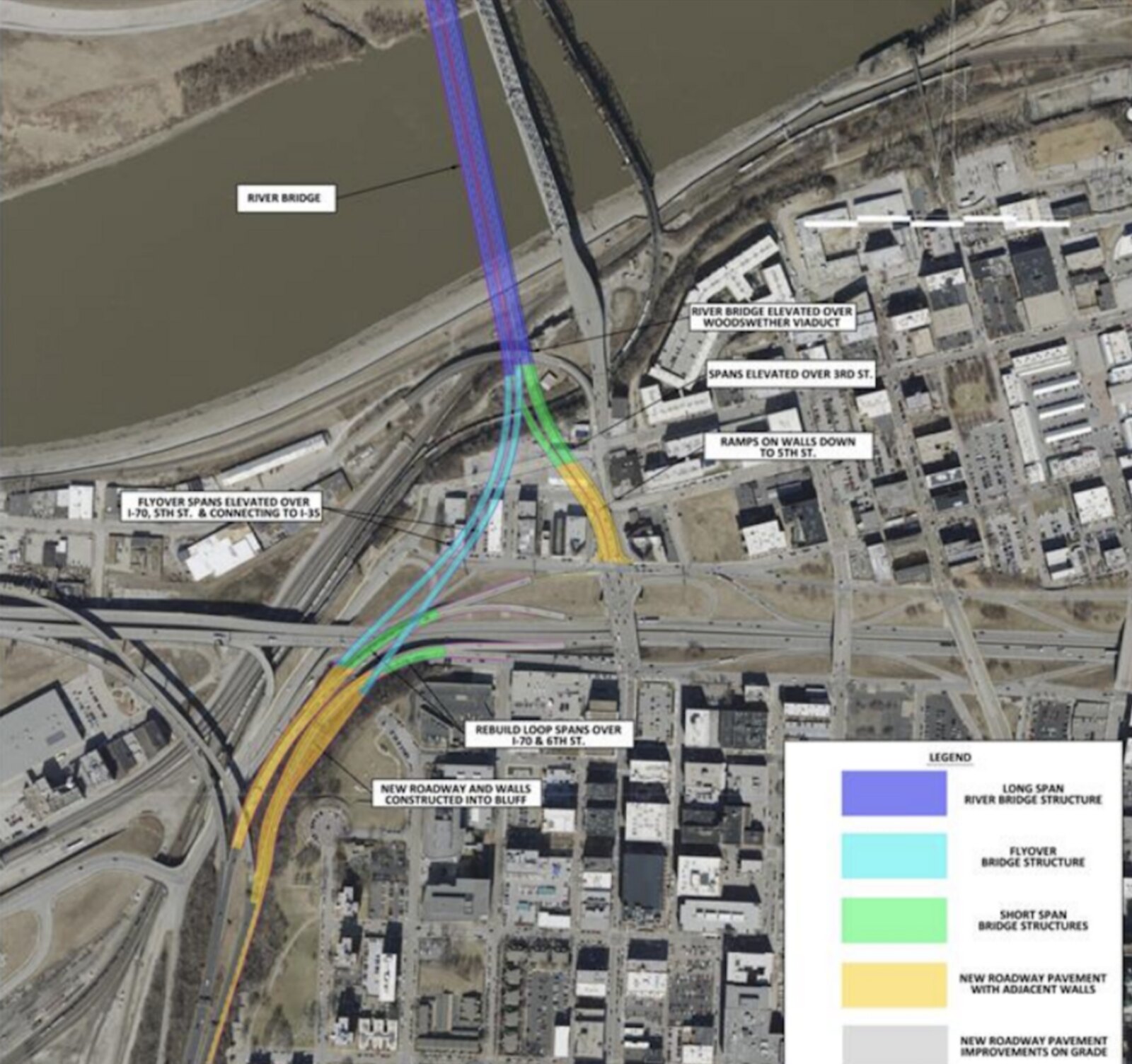
Don't know if this is new or not, but BizJournal says this is the preferred route of the bridge. Looks like it may require demolition of some structures.
Quote from the article...
The assessment also crystallized a preferred new bridge design, which calls for removal of the existing bridge, its south approach span and Broadway between Fourth and Fifth streets.
Under that design, the new bridge would be elevated over Woodswether Viaduct. Flyover spans elevated over Interstate 70 and Fifth Street would connect to I-35, while spans over 3rd Street and ramps on walls down to 5th Street would lead to an ultimate Broadway connection.
Compared to alternatives, the preferred design is expected to reduce regional travel times for commuters, reduce traffic volume on local streets and minimize conflict points at intersections. The design also is set to include a shared use path connection for bike and pedestrian access on Fifth Street.
Chris Stritzel wrote: ↑Fri Aug 14, 2020 2:27 pm
Don't know if this is new or not, but BizJournal says this is the preferred route of the bridge. Looks like it may require demolition of some structures.
Riverite wrote: ↑Fri Aug 14, 2020 2:49 pm
This thing has sidewalks and a bike path right? I’d love to see a bike path and park around the green space outside the downtown airports levee
If Broadway will be open during the duration of construction then the old bridge should be convertible into a pedestrian way.
From the environmental document:
All three build alternatives would include a dedicated and barrier-protected off-travelway bicycle/pedestrian facility along one side of the new crossing. Connectivity to existing walkways south of the river and to Richards Road north of the river would be provided off each bridge approach span. MoDOT will continue to coordinate the layout and location of the off-travelway bicycle/pedestrian facility with stakeholders through the Design- Build process.
South of the river, all build alternatives would cause temporary and permanent impacts to existing segments of the Riverfront Heritage Trail located along Beardsley Road and sections of 3rd and 4th Streets. Trail connectivity would be restored after completion of the project for all build alternatives. The Central and Adjacent Alternatives allow for continuity of the trail under the new bridge along a reconfigured 3rd Street to Beardsley Road. The West Alternative allows for continuity of the trail under the new bridge along a trail extension from 4th Street to Beardsley Road.
During construction, the trail will need to be temporarily closed in the vicinity of active work along Broadway, 3rd and 4th Streets and Beardsley Road. A possible trail detour during construction would travel from Wyandotte to 5th Street to Beardsley Road.
Impacts to the trail and planning for closures and detours will be coordinated by MoDOT with KCRT who manages the trail and associated trailheads. Because KCRT is a private, not-for-profit organization and not a public entity, the Riverfront Heritage Trail does not meet the definition of a resource that is provided protection under Section 4(f) of the DOT Act.
I never noticed until now that the project includes extending 3rd Street to connect to Beardsley. That's a huge improvement over the awkward jog currently required.