A new book on the history of Kansas City has been released in the past few weeks. It is written by James Shortridge, a geography professor from KU. Here's a link to a KC Star story book.
http://www.kansascity.com/2012/11/10/39 ... orama.html
I have only read the first chapter, twenty eight pages, and I believe I have learned or gained new perspective on at least fifty things about metro Kansas City and it's early development, and I consider myself an amatuer authority on the subject.
Many of you forumers; the history geeks, mapsters, statistic buffs and conspiracy theorists, will find intruiging facts, observations and data.
I heard Shortridge introduce his book, at the Central Library, a couple of weeks ago. He was not prepared for his assignment, certainly not the large crowd that responded to notice of his presentation. In fact his talk was so mediocre, that I put off starting to read the book until now. A very pleasant surprise. That whole "book and it's cover" thing.
Kansas City History
-
FangKC

- City Hall

- Posts: 18310
- Joined: Sat Jul 26, 2003 10:02 pm
- Location: Old Northeast -- Indian Mound
Re: Kansas City History
I am reading it as we speak. I, too, have learned a whole new perspective on how Kansas City developed, and why.
Especially interesting to me is new information about several attempts to change the state line so the city would be in one state or another.
Also fascinating is our geological history, and that Turkey Creek used to empty into the Blue River Valley basin and not the Kansas River basin. Apparently, Turkey Creek drainage was blocked by glacial deposits at one time, and the channel was pushed east, where the rail line out of Union Station runs over to Winner Road. Eventually, the glacial deposits gave way and Turkey Creek changed course through the West Bottoms.
North Kansas City was also platted by industrial concerns who wished to avoid paying taxes in KCMO. The residential portion was sort of an afterthought.
Westport grew primarly as a challenger to Independence because it was across the boundary to the Indian Territory, which were the trading posts' primary customer base for a time. Later, Westport become a more desired desparture point because of the ample grazing grounds with prairie grass were nearby--south of Westpor--for use by westward migrators and the scouting outfits to graze their horses and livestock--especially during the winter when travel came to a stop. The other factor was the difficulty fording the Blue River on the Santa Fe Trail from Independence. It was easier to disembark from a steamboat at Westport Landing and avoid the ford on the Blue River. It also cut two-to-four days off a trip.
Last edited by FangKC on Sun Nov 25, 2012 3:31 am, edited 1 time in total.
-
Highlander

- City Center Square
- Posts: 10225
- Joined: Mon Jun 28, 2004 1:40 pm
- Location: Houston
Re: Kansas City History
Too bad the state line move wasn't accomplished. That line hurts the city and Missouri just hasn't been kind to KC lately.FangKC wrote:I am reading it as we speak. I, too, have learned a whole new perspective on how Kansas City developed, and why.
Also fascinating is our geological history, and that Turkey Creek used to empty into the Blue River Valley basin and not the Kansas River basin. Apparently, Turkey Creek drainage was blocked by glacial deposits at one time, and the channel was pushed east, where the rail line out of Union Station runs over to Winner Road. Eventually, the glacial deposits gave way and Turkey Creek changed course through the West Bottoms.
Turkey Creek probably utilized the valley Winner Road follows and then the low area occupied by the tracks going through Union Station. There is was subsequent manmade change to the course of Turkey Creek, I think it now flows through a tunnel under the eastern end of the Argentine ridge prior to ever reaching the bottoms.
-
FangKC
- City Hall
- Posts: 18310
- Joined: Sat Jul 26, 2003 10:02 pm
- Location: Old Northeast -- Indian Mound
Re: Kansas City History
Several of the proposals to move the state line resulted in early Kansas City being part of Kansas, and not Missouri.
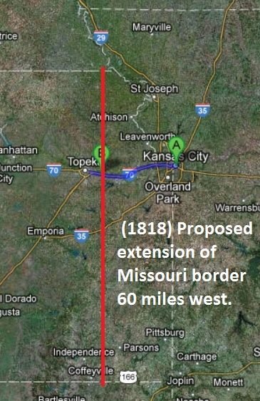
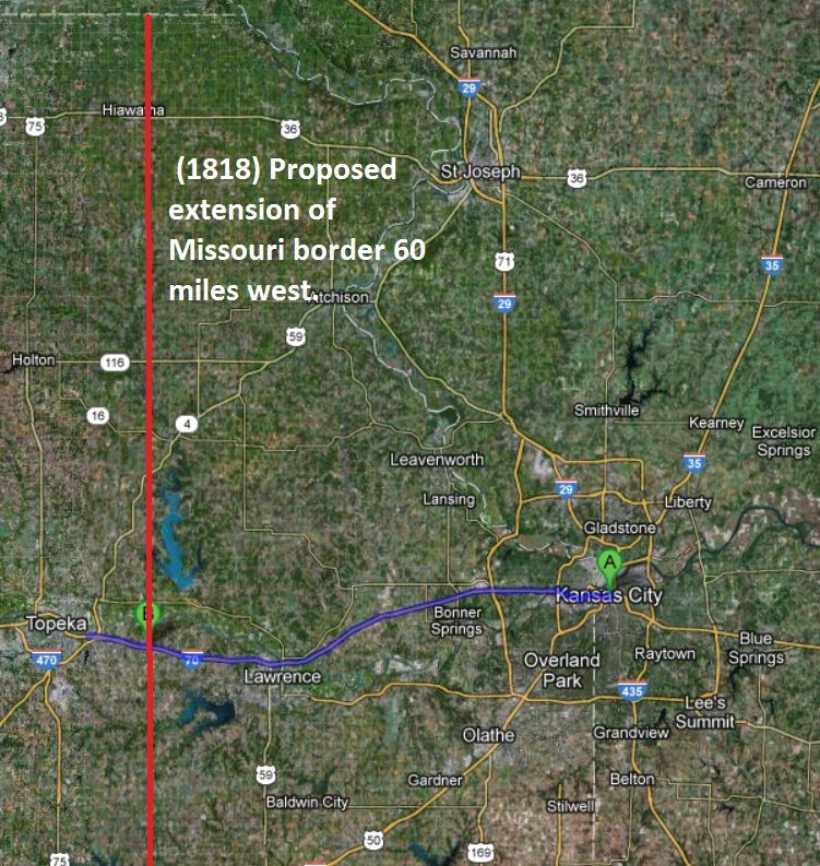
One early effort though proposed moving the state line 60 miles west of where it is now--into Kansas territory. Federal authorities opposed it because they already thought Missouri might be too large. At that time, the Missouri territory was larger than any existing state other than Virginia (this was before West Virginia became a state, and before the Platte Purchase was added to Missouri).
After 1850, there were four attempts to move the Town of Kansas and environs from the State of Missouri into the then Kansas Territory. A serious effort in 1855 proposed that all parts of Jackson County west of the Blue River from the Missouri River on the north, to Cass County on the south, would be placed in Kansas. It failed.
Then after the Civil War, there were three more attempts to move Kansas City, MO, into Kansas (in the 1870s). In 1873, the Kansas legislature appropriated funds to buy Kansas City from Missouri. The last major attempt, in 1878, the mayor of Kansas City put together a delegation and petitioned both the Missouri and Kansas legislatures to annex KCMO into Kansas. This effort also proposed Kansas City be annexed into Kansas from the Blue River west from the Missouri River south to Cass County. The Kansas legislature approved the measure, but Missouri's did not. Missouri did not want to give up tax revenue.
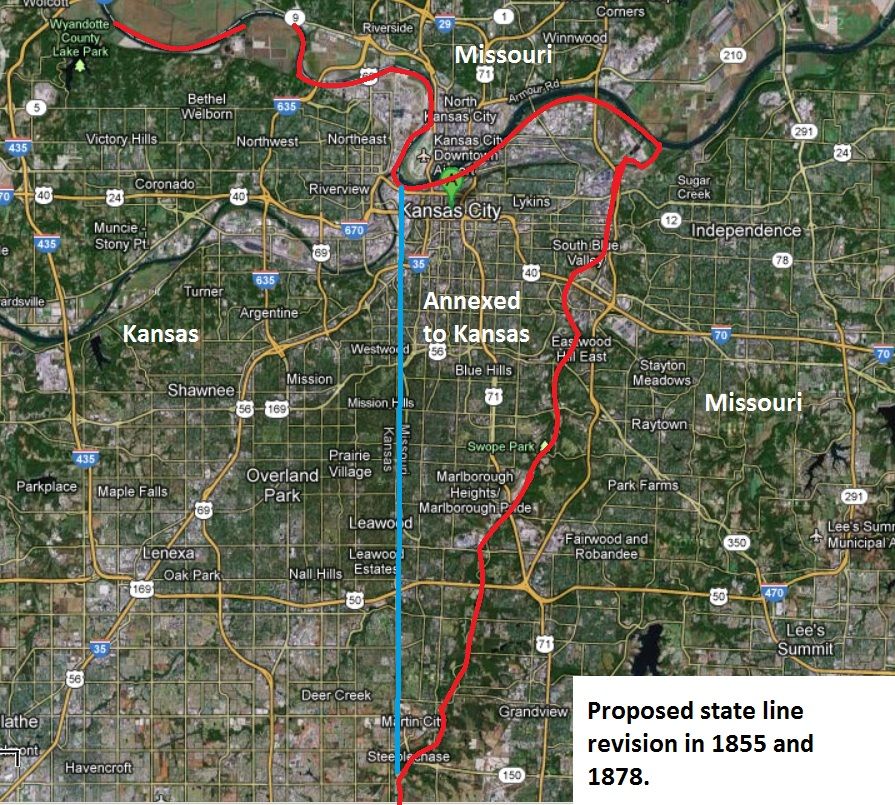
I don't know if this would have solved anything in the long run. Having KCMO west of the Blue River placed in Kansas would have still created a divided metropolitan area. The Northland would have been in Missouri. Independence, Blue Springs, Grain Valley, Raytown, Lee's Summit, Raymore, Grandview, and Belton would have been in Missouri.
I think the only scenario that might have worked would have been the one proposed in 1818. Moving the Missouri border 60 miles west, which would have placed it in a rural area halfway between Lawrence and Topeka. This border would most likely have met up at a location on the southern Nebraska border north of Hiawatha, Kansas--roughly following Highway 73, and just east of Coffeyville, KS, on the south.
The present Kansas-based cities of Ottawa, Ft. Scott, Parsons, Baldwin City, Chanute, Paola, Olathe, Gardner, Overland Park, Shawnee, Leawood, Roeland Park, Mission, Kansas City, KS, Lenexa, Prairie Village, Eudora, Tonganoxie, Spring Hill, Bonner Springs, Osawatomie, Pittsburg, Leavenworth, Lansing, Atchison, and Lawrence would have been in Missouri.
In 1818, Kansas was mostly undeveloped and had little population. That would have been the easiest opportunity to change the state line.
In 1818, federal officials worried about making the Missouri too big. However, with states the size of Alaska, Texas, California and Montana, it seems silly to have had that concern now. Those four states individually are at least twice as big in size as Missouri. Missouri ended up being only the 21st largest state in size. The State of Kansas actually turned out to be bigger in square miles than Missouri. Of course, these states were all admitted to the Union well after 1818.
One early effort though proposed moving the state line 60 miles west of where it is now--into Kansas territory. Federal authorities opposed it because they already thought Missouri might be too large. At that time, the Missouri territory was larger than any existing state other than Virginia (this was before West Virginia became a state, and before the Platte Purchase was added to Missouri).
After 1850, there were four attempts to move the Town of Kansas and environs from the State of Missouri into the then Kansas Territory. A serious effort in 1855 proposed that all parts of Jackson County west of the Blue River from the Missouri River on the north, to Cass County on the south, would be placed in Kansas. It failed.
Then after the Civil War, there were three more attempts to move Kansas City, MO, into Kansas (in the 1870s). In 1873, the Kansas legislature appropriated funds to buy Kansas City from Missouri. The last major attempt, in 1878, the mayor of Kansas City put together a delegation and petitioned both the Missouri and Kansas legislatures to annex KCMO into Kansas. This effort also proposed Kansas City be annexed into Kansas from the Blue River west from the Missouri River south to Cass County. The Kansas legislature approved the measure, but Missouri's did not. Missouri did not want to give up tax revenue.
I don't know if this would have solved anything in the long run. Having KCMO west of the Blue River placed in Kansas would have still created a divided metropolitan area. The Northland would have been in Missouri. Independence, Blue Springs, Grain Valley, Raytown, Lee's Summit, Raymore, Grandview, and Belton would have been in Missouri.
I think the only scenario that might have worked would have been the one proposed in 1818. Moving the Missouri border 60 miles west, which would have placed it in a rural area halfway between Lawrence and Topeka. This border would most likely have met up at a location on the southern Nebraska border north of Hiawatha, Kansas--roughly following Highway 73, and just east of Coffeyville, KS, on the south.
The present Kansas-based cities of Ottawa, Ft. Scott, Parsons, Baldwin City, Chanute, Paola, Olathe, Gardner, Overland Park, Shawnee, Leawood, Roeland Park, Mission, Kansas City, KS, Lenexa, Prairie Village, Eudora, Tonganoxie, Spring Hill, Bonner Springs, Osawatomie, Pittsburg, Leavenworth, Lansing, Atchison, and Lawrence would have been in Missouri.
In 1818, Kansas was mostly undeveloped and had little population. That would have been the easiest opportunity to change the state line.
In 1818, federal officials worried about making the Missouri too big. However, with states the size of Alaska, Texas, California and Montana, it seems silly to have had that concern now. Those four states individually are at least twice as big in size as Missouri. Missouri ended up being only the 21st largest state in size. The State of Kansas actually turned out to be bigger in square miles than Missouri. Of course, these states were all admitted to the Union well after 1818.
-
IraGlacialis
- Colonnade
- Posts: 895
- Joined: Tue Feb 12, 2008 10:02 pm
- Location: Bangkok
Re: Kansas City History
I'm also curious to know whether KC would've been the same if the border was rearranged pre-Civil War, or if Independence would have ended up becoming the equivalent to Kansas City today.
Even post-Civil War, there was still some animosity on the Missouri side towards Kansas due to the nastiness that occurred (even if the City of Kansas itself was spared the brunt of Order No. 11).
Even post-Civil War, there was still some animosity on the Missouri side towards Kansas due to the nastiness that occurred (even if the City of Kansas itself was spared the brunt of Order No. 11).
-
FangKC
- City Hall
- Posts: 18310
- Joined: Sat Jul 26, 2003 10:02 pm
- Location: Old Northeast -- Indian Mound
Re: Kansas City History
You should read the book. The author talks about some of the political reasons Kansas City, Missouri, sought to be in Kansas prior to the Civil War that had to do with bringing Kansas into the Union as a slave state, instead of a free state.
-
IraGlacialis
- Colonnade
- Posts: 895
- Joined: Tue Feb 12, 2008 10:02 pm
- Location: Bangkok
Re: Kansas City History
Yeah, I'd like to get my hands on that book as soon as I can, though it may be a while.
The explanation given for the City of Kansas' desire to be part of Kansas fits into the whole border unpleasantness scheme of things. Still, even if the mayor desired the move, I wonder what the actual populace would have thought of the idea post-Civil War.
Besides, if it had moved pre-Civil War and failed to shift the votes, history books may talk about the burning of CoK in addition to Lawrence.
I actually like the proposed westward boundary shift (if it had happened earlier of course). Though, IMHO, the line would have been more reasonable to start at the western-pointing bend where Atchison is (the area towards St. Joseph would still be part of Kansas). It not only demands much less land, but allows for a geographical marker instead of some arbitrary distance-based line.
-
FangKC
- City Hall
- Posts: 18310
- Joined: Sat Jul 26, 2003 10:02 pm
- Location: Old Northeast -- Indian Mound
Re: Kansas City History
I've recreated placements of various sites mentioned in the book using Google maps of present-day Kansas City.
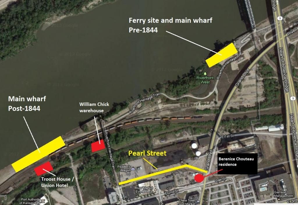
Shown are various historic locations of early Kansas City sites including Chouteau Landing, Francois Chouteau's trading post and farm, the William Chick warehouse, Pearl Street, Troost House/Union Hotel, and the placement of early wharves. The first Chouteau landing site was on the north side of the Missouri River between the Chouteau Bridge and 435 Bridge in present day Randolph. From my reading, the Chouteau landing site was moved three times--with two of them being on the south side of the Missouri.
Another thing of note is that the present river bank on the south side of the Missouri is not the original one. Berkley Riverfront Park sites on infill dirt. The river's edge used to be further south. So the Chouteau Landing site show on the illustration is not exact. The actual site probably sat further back. From old photos I've seen of the riverbank in the 1870s, the bank was craggy and uneven.
Grand Avenue was called Market Street, and it was the first passage through the bluffs--mostly because of natural topography made it the easiest to carve out a road. The reason Grand Avenue makes a turn east at 3rd Street is because it followed the easiest and most natural path down the bluff.
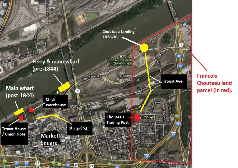
-
FangKC
- City Hall
- Posts: 18310
- Joined: Sat Jul 26, 2003 10:02 pm
- Location: Old Northeast -- Indian Mound
Re: Kansas City History
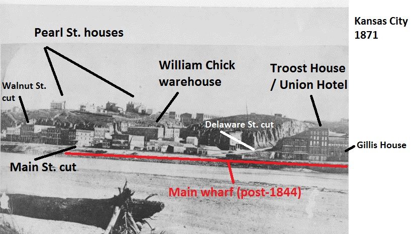
This image shows the placement of the wharves, Pearl Street, and the house of the widowed Berenice Chouteau on the SW corner of Pearl and Market Street (later Grand). Pearl Street doesn't exist any longer. It is the location of the coal yards for the steam plant on Grand, and the KCPL transformer yard. Pearl Street ran east to west between Market (Grand) and Walnut, and was north of Second Street between First and Second. Among the earliest businesses were Troost House/Union Hotel and the William Chick warehouse.
-
FangKC
- City Hall
- Posts: 18310
- Joined: Sat Jul 26, 2003 10:02 pm
- Location: Old Northeast -- Indian Mound
Re: Kansas City History
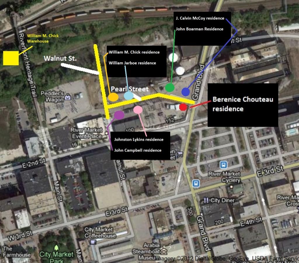
This image shows the location of Pearl Street, and the people who had houses there.
-
FangKC
- City Hall
- Posts: 18310
- Joined: Sat Jul 26, 2003 10:02 pm
- Location: Old Northeast -- Indian Mound
Re: Kansas City History
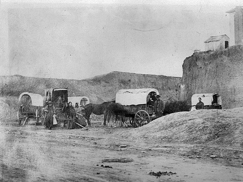
Covered wagons at Second Street and Delaware in 1869.
-
FangKC
- City Hall
- Posts: 18310
- Joined: Sat Jul 26, 2003 10:02 pm
- Location: Old Northeast -- Indian Mound
Re: Kansas City History
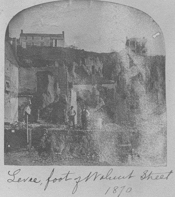
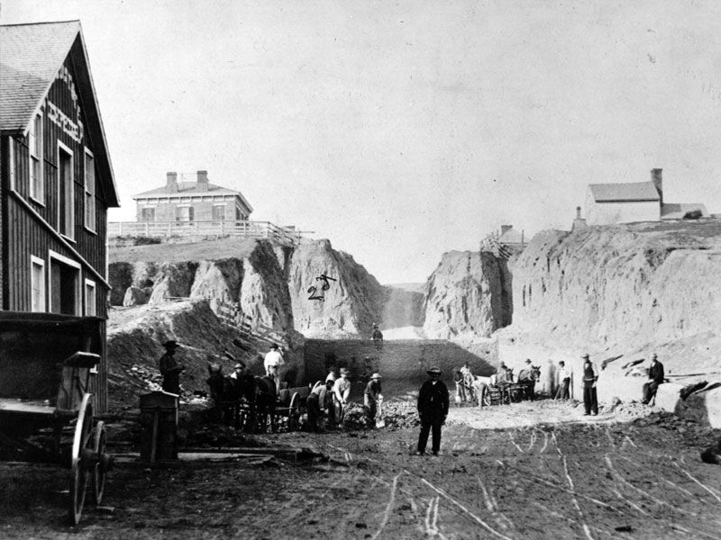
Excavation in 1870 near the Walnut St. cut show what appear to be houses on Pearl Street in the background.
-
FangKC
- City Hall
- Posts: 18310
- Joined: Sat Jul 26, 2003 10:02 pm
- Location: Old Northeast -- Indian Mound
Re: Kansas City History
Kansas City riverfront in 1871 with Pearl Street residences indicated as well as Chick warehouse, the wharf, and Troost House/Union Hotel, which later became Gillis House.
-
FangKC
- City Hall
- Posts: 18310
- Joined: Sat Jul 26, 2003 10:02 pm
- Location: Old Northeast -- Indian Mound
Re: Kansas City History
1868 image shows Walnut Street at Third Street looking north towards Second Street and the bluffs next to the river.
-
maison rustique
- Pad site
- Posts: 89
- Joined: Tue Apr 06, 2010 7:28 am
Re: Kansas City History
Fascinating stuff--thanks so much!!
-
shinatoo
- Ambassador
- Posts: 7456
- Joined: Wed Jan 19, 2005 3:20 pm
Re: Kansas City History
Is all of the hilltop downtown loess? It looks like what they were digging in those pics. How far down is the bedrock?
-
KCMax

- Global Moderator

- Posts: 24051
- Joined: Wed Aug 04, 2004 3:31 pm
- Location: The basement of a Ross Dress for Less
- Contact:
Re: Kansas City History
Will have to check it out. Thanks for the rec.
-
loftguy
- Bryant Building
- Posts: 3850
- Joined: Fri Sep 16, 2005 12:12 pm
Re: Kansas City History
shinatoo wrote:Is all of the hilltop downtown loess? It looks like what they were digging in those pics. How far down is the bedrock?
Supposedly, when the loess was removed, either side of second street in 1867-1872, the bluff was taken down 40 to 100 feet, to bedrock.
However, the bluff geology is not uniform, and there were a series of gullies that cut through the bluff down to the river. These gullies roughly coincided with many of the streets that now exist, Grand(Market), Walnut, Delaware, Main, and Broadway.
In the recent past, there have been drillings, either side of third street in the River Market, for building piers, elevator hydraulic shafts, etc... that have gone as deep as 65 feet without hitting bedrock.
Last edited by loftguy on Mon Nov 26, 2012 11:36 am, edited 1 time in total.
-
pash
- Bryant Building
- Posts: 3800
- Joined: Sun Feb 20, 2011 2:47 am
-
zonk
- Alameda Tower
- Posts: 1250
- Joined: Sun Oct 12, 2003 12:07 pm
- Location: downtown
Re: Kansas City History
I heard a rumor a long time ago that Delaware Street was actually filled in one story to the current street level. That would make the basements the former ground level. And in some buildings you can actually see the old front doors in the basement. When they were cutting the bluffs down they dumped the material in the streets....Sounds crazy to me, but intriguing. Loftguy/Fang/anyone heard anything crazy like this?loftguy wrote:shinatoo wrote:Is all of the hilltop downtown loess? It looks like what they were digging in those pics. How far down is the bedrock?
Supposedly, when the loess was removed, either side of second street in 1867-1872, the bluff was taken down 40 to 100 feet, to bedrock.
However, the bluff geology is not uniform, and there were a series of gullies that cut through the bluff down to the river. These gullies roughly coincided with many of the streets that now exist, Grand(Market), Walnut, Delaware, Main, and Broadway.
In the recent past, there have been drillings, either side of third street in the River Market, for building piers, elevator hydraulic shafts, etc... that have gone as deep as 65 feet without hitting bedrock.