Page 1 of 1
Hurricane Thread
Posted: Sun Sep 03, 2017 11:11 am
by earthling
Starting a new thread since Houston hurricane is over and it was in Houston thread. Hurricane Irma up next.
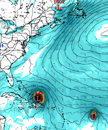
Here's the latest from National Hurricane Center (Sun Morning Aug 3). The 3 day forecast is considered generally accurate so Virgin Islands (and others nearby) likely to get hit and then Puerto Rico impacted in some way. The 5 day is consider somewhat speculative, indicating that the Bahamas could get hit. The models after that are considered highly speculative but nearly all (as of this morning) show riding up Florida coast and up to around the Carolinas.. One model (JMA) thinks a dead on hit to Ft Lauderdale/N Miami area. A couple show chance of it slipping into the Gulf. Euro model still shows various paths go out to sea.

If Jose forms behind it, so far expected to be weaker - a couple models show it turning up sooner, approaching Canada or turning out to sea very early.
Here are various models, set to North Atlantic region and click play...
https://www.tropicaltidbits.com/analysi ... 1319580078
Re: Hurricane Thread
Posted: Mon Sep 04, 2017 8:57 am
by earthling
It's been 100+ years since two hurricanes hit landfall on continental US in same hurricane season.
The Monday morning 5-day cone now shows Irma dipping SW towards Cuba instead of central Bahamas (compared to 5 day cone yesterday).
Leeway and Virgin Islands looking to get CAT3-4 direct hits early Wed. NOAA has changed from watch to warnings just now. This link auto-updates ever 6 hours...

The models after that (consider them highly speculative) now show potentially running up Gulf Coast as an option - generally along FL W coast. Pretty much all models show no option for going 'out to sea' (OTS), even the Euro models which showed only chance earlier.


Re: Hurricane Thread
Posted: Mon Sep 04, 2017 12:57 pm
by earthling
Entirely speculative and way way too early to mean anything but the possibility of Jose forming behind Irma has a wacky path according to one model. Does a loop-d-loop, hits Bahamas and then NC. Take with grain of salt as the models are seeing strange things due to chaotic troughs/ridges in N Atlantic and Central US...
BTW, even Euro model also says Irma to now hit Miami and South Carolina. Doesn't take much to change path within 5 days though. Could still head towards Gulf or even OTS.
Re: Hurricane Thread
Posted: Tue Sep 05, 2017 7:59 am
by earthling
Irma is hitting Category 5, over 150MPH (peaks over 170) and about the hit the islands. Have experienced 75Mph peaks in FL and was alarming, can't imagine 150+.
The two major models (GFS and Euro) still show hitting S Florida/Miami area around late Sat to Sun morning but other models show possibly gong into Gulf. Continental US landfall somewhere is looking more and more likely, but hopefully it finds a way to go out to sea - any change in troughs/ridges can redirect it.
Again the range in the 3 day cone is pretty likely, the 5 day is somewhat speculative and models beyond that are considered highly speculative...
Here are models. Click Regions (set to N Atlantic) then click Play. GFS is one of the major models. ECMWF is the Euro model, which can be selected from menu.
https://www.tropicaltidbits.com/analysis/models/
Re: Hurricane Thread
Posted: Tue Sep 05, 2017 8:09 am
by earthling
Here are live cams from St. Barts, one of first islands to get hit. Will be interesting to see what goes out first, the live cam or that palm tree...
http://st-barth.com/livecam3.html
Re: Hurricane Thread
Posted: Tue Sep 05, 2017 3:00 pm
by brewcrew1000
If the Tampa/Dolphins game has to move wonder if KC would be the likely spot to host the game. They have until today to move it up in the week. Otherwise Alternative spots are going to be picked. KC seems like the perfect spot to host this game.
Re: Hurricane Thread
Posted: Tue Sep 05, 2017 3:56 pm
by bobbyhawks
brewcrew1000 wrote:If the Tampa/Dolphins game has to move wonder if KC would be the likely spot to host the game. They have until today to move it up in the week. Otherwise Alternative spots are going to be picked. KC seems like the perfect spot to host this game.
Don't they also have the same bye week? It seems it would be easier (financially) for them to just move the game to the bye week.
Re: Hurricane Thread
Posted: Tue Sep 05, 2017 4:29 pm
by brewcrew1000
The Dolphins also have a London game in October, they should just scrap the Dolphins from the London game and give them back a home game. I don't think both teams want to play 16 straight games.
Re: Hurricane Thread
Posted: Tue Sep 05, 2017 4:33 pm
by earthling
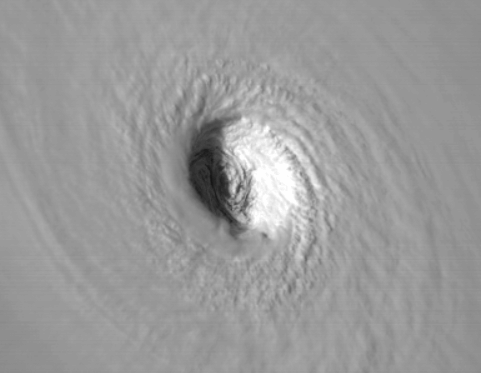
Dramatic pic of the eye approaching the islands. The eye is 30 miles wide and 10 miles deep. Can see the sunset shadow within the eye..
Storm approaching St. Barts, waters in harbor getting rough. Live cam...
http://st-barth.com/livecam3.html
Anguilla island...
http://www.earthcam.com/world/anguilla/ ... =barnesbay
Re: Hurricane Thread
Posted: Wed Sep 06, 2017 6:36 am
by grovester
Palm tree is still holding in St. Barts, but just barely.
Re: Hurricane Thread
Posted: Wed Sep 06, 2017 8:26 am
by earthling
^That St. Barts cam went dead overnight and is showing a recorded loop. It went dead when winds were about 130. If you right click and get 'stats for nerds', it shows how long ago it went dead. Even official weather equipment on several islands were knocked out.
Here's a cam in British Virgin Islands, which should be hit this morning, maybe see high winds in a hour or so...
https://www.youtube.com/watch?v=IjGdi7z_B4U
Re: Hurricane Thread
Posted: Wed Sep 06, 2017 9:04 am
by shinatoo
4 of the seven cameras are still live, but you can't see anything other than a shadowy tree on one of them.
Re: Hurricane Thread
Posted: Wed Sep 06, 2017 6:17 pm
by earthling
"Up to" 90% of Barbuda island damaged or destroyed. Even if exaggerated, sounds significant.
http://www.bbc.com/news/world-latin-america-41172726
Re: Hurricane Thread
Posted: Thu Sep 07, 2017 10:13 am
by earthling
Three day 3 forecasts are generally more accurate and Florida is now within 3 days. Euro shows Miami gets hit, GFS shows just E of Miami, National Hurricane Service currently shows a Miami hit or just E. Some think Jose could help pull Irma away from Florida to E. Not looking good for the Carolinas either way.
Too early to call but Euro model has Jose behind Irma also hitting S Florida. Click play and watch the 2nd hurricane...
https://www.tropicaltidbits.com/analysi ... 0700&fh=24
Re: Hurricane Thread
Posted: Fri Sep 08, 2017 3:33 pm
by earthling
Andrew in 1992 compared to Irma. Andrew spent 4 hours over Florida, Irma expected to be 30 hours.

Re: Hurricane Thread
Posted: Sat Sep 09, 2017 9:52 pm
by earthling
The ocean is missing off coast of a Bahamas island...
https://www.washingtonpost.com/news/cap ... 2#comments