Page 28 of 33
Re: Postcards From the Edge of Time
Posted: Sat Jan 02, 2021 6:43 am
by FangKC
Municipal Wharf at Main Street (location is where the Main Street pedestrian bridge and lookout is now)
https://www.google.com/maps/@39.1129416 ... !1e3?hl=en


Re: Postcards From the Edge of Time
Posted: Sat Jan 02, 2021 7:12 am
by FangKC
U.S. Courthouse and Post Office at 8th and Grand in 1908. The building's construction began in 1892, and was completed in 1900. The building was raised in 1938 for construction of the existing former federal courthouse. The first Grand Avenue Temple is behind it at 9th and Grand.

In 1900, on the right background is the U.S. Courthouse and Post Office. Right foreground is the Studebaker Brothers sign. On the left is the Midland Hotel.

A postcard showing the U.S. Courthouse. Behind the dome--in the distance--is the Jackson County Courthouse at Missouri and Locust. In the right foreground is the steeple of the first Grand Avenue Temple. The Scarritt Building is on the left.

The U.S. Courthouse under construction in 1900. The Victoria Hotel is on the right in the background.

The finished Courthouse in 1900.

Re: Postcards From the Edge of Time
Posted: Fri Mar 26, 2021 9:36 pm
by TheLastGentleman
Re: Postcards From the Edge of Time
Posted: Wed Mar 31, 2021 2:56 pm
by flyingember
Interesting paper. It's showing peak 1920s hubris.
Peak stock market was two days later.
Re: Postcards From the Edge of Time
Posted: Sun Apr 04, 2021 7:44 pm
by Rabble
These are both great pictures I missed seeing in January. The foundation and floor of the wharf still exists and this would be a simple building to recreate. What a wonderful location to get on a excursion boat and travel up to Parkville, explore the Kaw, or go downriver to Lexington.
Re: Postcards From the Edge of Time
Posted: Wed Apr 07, 2021 5:39 pm
by normalthings
Rabble wrote: ↑Sun Apr 04, 2021 7:44 pm
These are both great pictures I missed seeing in January. The foundation and floor of the wharf still exists and this would be a simple building to recreate. What a wonderful location to get on a excursion boat and travel up to Parkville, explore the Kaw, or go downriver to Lexington.
Port KC is studying the wharf as we speak
Re: Postcards From the Edge of Time
Posted: Fri Apr 09, 2021 8:07 am
by Rabble
normalthings wrote: ↑Wed Apr 07, 2021 5:39 pm
Port KC is studying the wharf as we speak
They will need to improve access. The old Grand Ave viaduct had an exit ramp to the wharf that still partially exists.
They should include a catfish restaurant in their plans that serves very cold beer.
Re: Postcards From the Edge of Time
Posted: Fri Apr 09, 2021 9:21 am
by shinatoo
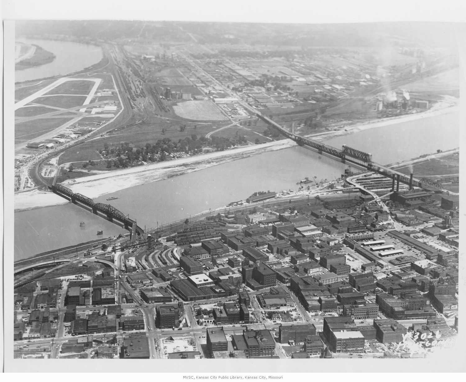
Wonder why there is such a dramatic curve coming out of the rail yard and approaching the Hannibal bridge?
Re: Postcards From the Edge of Time
Posted: Fri Apr 09, 2021 10:56 am
by normalthings
shinatoo wrote: ↑Fri Apr 09, 2021 9:21 am
Wonder why there is such a dramatic curve coming out of the rail yard and approaching the Hannibal bridge?
Maybe rail yard is too low?
Re: Postcards From the Edge of Time
Posted: Fri Apr 09, 2021 11:03 am
by moderne
Just east of the Hannibal bridge is a limestone shelf projecting onto the river. It is a remnant of the original steamboat landing, the Plymouth rock of KC. Wish there was some way to call some attention to it as it is the reason KC is where it is.
Re: Postcards From the Edge of Time
Posted: Fri Apr 16, 2021 2:26 pm
by flyingember
moderne wrote: ↑Fri Apr 09, 2021 11:03 am
Just east of the Hannibal bridge is a limestone shelf projecting onto the river. It is a remnant of the original steamboat landing, the Plymouth rock of KC. Wish there was some way to call some attention to it as it is the reason KC is where it is.
Your history is a bit off, especially if you want to use the term "Plymouth Rock"
The original landing and settlement of today's modern city was in 1826 around the foot of Troost. This was part of the French settlement that built up at the Chouteau Trading Post. The original town site was the Prudhomme Farm, and he was there because of Chouteau.
Westport Landing wasn't founded until 1834. My guess is they didn't want to pay to use the existing landing.
Re: Postcards From the Edge of Time
Posted: Sat Apr 17, 2021 9:23 am
by moderne
Re: Postcards From the Edge of Time
Posted: Mon Apr 19, 2021 9:51 pm
by Rabble
Great information, thank you.
Re: Postcards From the Edge of Time
Posted: Wed Apr 21, 2021 3:45 pm
by Highlander
That was a great read.
The Bethany Falls is also the limestone unit that houses the Subtropolis (the underground cave storage area in KC). A tremendous amount of Loess material has been removed from downtown probably taking 20-30' off the crest of the hill. You can still see how thick loess deposits in the KC area were in the road cuts of the N-S major highways where they cut through the bluffs into the Missouri River valley (example below from I435). Courtesy of continental glaciation.
https://www.google.com/maps/@39.1109344 ... 92!5m1!1e4
Re: Postcards From the Edge of Time
Posted: Wed Apr 21, 2021 4:41 pm
by shinatoo
I thought loess was the result of wind carried fine particles. Eolian?
Re: Postcards From the Edge of Time
Posted: Wed Apr 21, 2021 6:59 pm
by Highlander
shinatoo wrote: ↑Wed Apr 21, 2021 4:41 pm
I thought loess was the result of wind carried fine particles. Eolian?
It is, but the precursor material is glacial; the fine particles are pulverized rock pushed south by glacial advance. The Missouri River around Kansas City was the southernmost advance and the remaining material gets entrained in the wind and deposited on the surrounding bluffs.
Re: Postcards From the Edge of Time
Posted: Wed Apr 21, 2021 7:37 pm
by FangKC
This Loess bluff, along Highway 210 at N. Brighton, is being slowly removed. I assume it's for fill dirt. Eventually they will have a flat site to develop.
https://www.google.com/maps/@39.149730 ... !1e3?hl=en
Re: Postcards From the Edge of Time
Posted: Thu Apr 22, 2021 8:00 am
by shinatoo
Highlander wrote: ↑Wed Apr 21, 2021 6:59 pm
shinatoo wrote: ↑Wed Apr 21, 2021 4:41 pm
I thought loess was the result of wind carried fine particles. Eolian?
It is, but the precursor material is glacial; the fine particles are pulverized rock pushed south by glacial advance. The Missouri River around Kansas City was the southernmost advance and the remaining material gets entrained in the wind and deposited on the surrounding bluffs.
Thanks. I was just shocked I remembered "Eolian".
Re: Postcards From the Edge of Time
Posted: Thu Apr 22, 2021 4:52 pm
by moderne
Do the limestone beds in the area tilt? There is a trail at Burrwoods called the Bethany Falls trail and there this bed is on the highest exposed layer above the Little Blue watershed.
Re: Postcards From the Edge of Time
Posted: Mon Apr 26, 2021 12:48 am
by FangKC
This Fred Harvey postcard shows a scene near the Municipal Wharf at First and Main streets. Two steamboats are docking. One of them is the steamer Chester. The Chester was a regular packet that traveled between St. Louis and Kansas City. The Chester was owned by the Kansas City Transportation and Steamship Company.
http://northeastnews.net/pages/steaming ... %20Chester


