Page 1 of 1
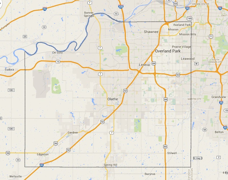
What are the Boundaries of "Northeast Johnson County"?
Posted: Wed Oct 22, 2014 5:38 pm
by slimwhitman
I have seen many raggers reference discrepancies of what they think of as "NE JoCo".
What are the west and south boundaries in your mind?
West: Roe? Nall? Metcalf? Antioch? Quivira? I-35? I-435?
South: 75th St? 87th St? 95th St? I-435? College Blvd? 119th St?
For me, it is Metcalf(west) (but could slip to Antioch or I-35/69 Hwy)....and I-435(south)
Re: What are the Boundaries of "Northeast Johnson County"?
Posted: Wed Oct 22, 2014 6:10 pm
by grovester
87th to the south and Antioch to the west.
Re: What are the Boundaries of "Northeast Johnson County"?
Posted: Wed Oct 22, 2014 8:58 pm
by flyingember
http://nejcchamber.com/cities-we-serve/
Fairway, Merriam, Mission, Mission Hills, Mission Woods, Prairie Village, Roeland Park, Westwood, Westwood Hills, Northern OP
That's Basically to Switzer and 95th.
Eyeballing it, that's roughly the NE quarter of the NE quarter of the county. The center is somewhere around K7 and I-35
In 1970 that would be a fair NE aspect given the populated parts of JoCo didn't go much past 435.
Now that there's OP home developments nearing 175th and Shawnee is working toward K7, I'd say NE JoCo is anything inside 435.
Re: What are the Boundaries of "Northeast Johnson County"?
Posted: Wed Oct 22, 2014 9:19 pm
by grovester
flyingember wrote:http://nejcchamber.com/cities-we-serve/
Fairway, Merriam, Mission, Mission Hills, Mission Woods, Prairie Village, Roeland Park, Westwood, Westwood Hills, Northern OP
That's Basically to Switzer and 95th.
Eyeballing it, that's roughly the NE quarter of the NE quarter of the county. The center is somewhere around K7 and I-35
In 1970 that would be a fair NE aspect given the populated parts of JoCo didn't go much past 435.
Now that there's OP home developments nearing 175th and Shawnee is working toward K7, I'd say NE JoCo is anything inside 435.
By that logic, the NE United States stretches west to the Dakotas and south to Indy. We all know that's not what anyone means.
Re: What are the Boundaries of "Northeast Johnson County"?
Posted: Wed Oct 22, 2014 9:50 pm
by flyingember
grovester wrote:flyingember wrote:http://nejcchamber.com/cities-we-serve/
Fairway, Merriam, Mission, Mission Hills, Mission Woods, Prairie Village, Roeland Park, Westwood, Westwood Hills, Northern OP
That's Basically to Switzer and 95th.
Eyeballing it, that's roughly the NE quarter of the NE quarter of the county. The center is somewhere around K7 and I-35
In 1970 that would be a fair NE aspect given the populated parts of JoCo didn't go much past 435.
Now that there's OP home developments nearing 175th and Shawnee is working toward K7, I'd say NE JoCo is anything inside 435.
By that logic, the NE United States stretches west to the Dakotas and south to Indy. We all know that's not what anyone means.
538 did a couple pieces on this. You would be surprised how few people has Missouri in the midwest
Re: What are the Boundaries of "Northeast Johnson County"?
Posted: Thu Oct 23, 2014 6:35 am
by AlbertHammond
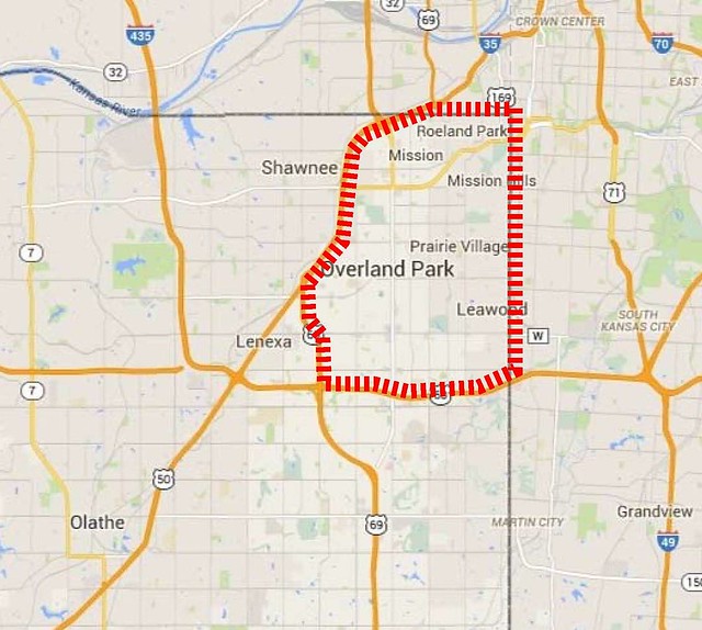
The more I look at it, this is my boundary (the highways are such barriers):
Re: What are the Boundaries of "Northeast Johnson County"?
Posted: Thu Oct 23, 2014 7:05 am
by mgsports
I second last post.
Re: What are the Boundaries of "Northeast Johnson County"?
Posted: Thu Oct 23, 2014 7:20 am
by aknowledgeableperson
I would agree for the most part except for the area around Shawnee. There are parts of Shawnee west of the highway that have been developed for some time and were connected to the rest of the developed area of JoCo.
Re: What are the Boundaries of "Northeast Johnson County"?
Posted: Thu Oct 23, 2014 9:03 am
by bbqboy
Shawnee Mission school district boundaries.
Re: What are the Boundaries of "Northeast Johnson County"?
Posted: Thu Oct 23, 2014 10:42 am
by flyingember
bbqboy wrote:Shawnee Mission school district boundaries.
http://maps.jocogov.org/ims/
pick the school districts layer and that's basically everything inside 435
Re: What are the Boundaries of "Northeast Johnson County"?
Posted: Thu Oct 23, 2014 8:22 pm
by Highlander
flyingember wrote:grovester wrote:flyingember wrote:http://nejcchamber.com/cities-we-serve/
Fairway, Merriam, Mission, Mission Hills, Mission Woods, Prairie Village, Roeland Park, Westwood, Westwood Hills, Northern OP
That's Basically to Switzer and 95th.
Eyeballing it, that's roughly the NE quarter of the NE quarter of the county. The center is somewhere around K7 and I-35
In 1970 that would be a fair NE aspect given the populated parts of JoCo didn't go much past 435.
Now that there's OP home developments nearing 175th and Shawnee is working toward K7, I'd say NE JoCo is anything inside 435.
By that logic, the NE United States stretches west to the Dakotas and south to Indy. We all know that's not what anyone means.
538 did a couple pieces on this. You would be surprised how few people has Missouri in the midwest
Where did they put Missouri? Please tell me it wasn't the south.
NE Johnson County = Roeland Park, Mission, Shawnee, Merriam. I actually put the dividing line at Johnson Drive/Shawnee Mission Parkway.
Re: What are the Boundaries of "Northeast Johnson County"?
Posted: Fri Oct 24, 2014 7:22 am
by flyingember
Highlander wrote:flyingember wrote:
538 did a couple pieces on this. You would be surprised how few people has Missouri in the midwest
Where did they put Missouri? Please tell me it wasn't the south.
NE Johnson County = Roeland Park, Mission, Shawnee, Merriam. I actually put the dividing line at Johnson Drive/Shawnee Mission Parkway.
between 10-20% say MO is in the south
http://fivethirtyeight.com/datalab/whic ... the-south/
30-40% say it's in the midwest
http://fivethirtyeight.com/datalab/what ... e-midwest/
think about the historical and local perspective involved in that.
Now look at this question. There's a clear quartering going on with one's perspective. But it's based entirely on what stage of JoCos suburban growth you use to define it. Is it the NE part of the pre-1970s area, which fits into existing naming conventions, or is based on the modern sprawl patterns to where pre-1970s is the old part.
I bet you'd see similar based on the age of the population. Ask a HS student from Olathe NW versus a senior citizen living in downtown OP.
Re: What are the Boundaries of "Northeast Johnson County"?
Posted: Fri Oct 24, 2014 8:23 am
by aknowledgeableperson
If you want to go with the 1970 cutoff date then use the Shawnee Mission SD boundaries. At the time it had three large high schools while the other school districts had just one high school each and all were not that large. At that time development in JoCo was mainly north/south along the state line. Lenexa and Olathe were mainly sleepy burbs each surrounded by farmland. There was some development to connect the city of Shawnee to the rest of the county along Johnson Drive.
Re: What are the Boundaries of "Northeast Johnson County"?
Posted: Fri Oct 24, 2014 10:22 am
by bbqboy
SMNW opened for the 69-70 school year, making 5 for the district.
Shawnee was very connected to the rest of nejoco.
Re: What are the Boundaries of "Northeast Johnson County"?
Posted: Fri Oct 24, 2014 8:47 pm
by aknowledgeableperson
Boy, I didn't remember those schools, West(62) and Northwest, being open at that time. West even opened before South(67).