I haven't been down there since they were painted, so I was just wondering how it was poorly executed. I don't doubt it's the case, just curious what specifically. What I've been hearing (see above) is the parking issue where you end up with traffic lanes on either side of the bike lane during parts of the day. That sounds incredibly dangerous.KCPowercat wrote:Yeah... I think it was poorly executed. What additional insight were you looking for?
Bike Lanes
-
smh

- Supporter
- Posts: 4330
- Joined: Tue Jun 08, 2010 10:40 pm
- Location: Central Loop
Re: Bike Lanes
-
KCPowercat

- Ambassador
- Posts: 34059
- Joined: Mon Oct 07, 2002 12:49 pm
- Location: Quality Hill
- Contact:
Re: Bike Lanes
Yeah there is that... And the lanes themselves are very short lived. The other is just a bike symbol in the middle of the right lane.... Then it just disappears all together. Seems very thrown together and not a consistent approach which is what we need in kc since people/drivers are still largely ignorant to bikes.
Seems like something that would have been done 10 years ago... Not 2012 with a bike/ped advisory group overseeing it.
Seems like something that would have been done 10 years ago... Not 2012 with a bike/ped advisory group overseeing it.
-
smh
- Supporter
- Posts: 4330
- Joined: Tue Jun 08, 2010 10:40 pm
- Location: Central Loop
Re: Bike Lanes
Got it. I wonder why they only went with sharrows into the Crossroads? Not enough right-of-way for our beautiful cars?KCPowercat wrote:Yeah there is that... And the lanes themselves are very short lived. The other is just a bike symbol in the middle of the right lane.... Then it just disappears all together. Seems very thrown together and not a consistent approach which is what we need in kc since people/drivers are still largely ignorant to bikes.
Seems like something that would have been done 10 years ago... Not 2012 with a bike/ped advisory group overseeing it.
-
flyingember
- Mark Twain Tower

- Posts: 9862
- Joined: Tue Jul 17, 2012 7:54 am
Re: Bike Lanes
cheaper. dedicated bike lanes require redoing a solid line for a distancesmh wrote:Got it. I wonder why they only went with sharrows into the Crossroads? Not enough right-of-way for our beautiful cars?KCPowercat wrote:Yeah there is that... And the lanes themselves are very short lived. The other is just a bike symbol in the middle of the right lane.... Then it just disappears all together. Seems very thrown together and not a consistent approach which is what we need in kc since people/drivers are still largely ignorant to bikes.
Seems like something that would have been done 10 years ago... Not 2012 with a bike/ped advisory group overseeing it.
easier to put in. you don't need to rethink lane widths the whole way across
-
KCPowercat
- Ambassador
- Posts: 34059
- Joined: Mon Oct 07, 2002 12:49 pm
- Location: Quality Hill
- Contact:
Re: Bike Lanes
But that's the thing, sw blvd was all repaved... Perfect time to change the parking to back end, create a true bike lane the entire way. Seems bikes were simply given lip service and the city is patting themselves on the back for being so progressive.
-
shinatoo
- Ambassador
- Posts: 7447
- Joined: Wed Jan 19, 2005 3:20 pm
Re: Bike Lanes
Out along 150 between Lees Summit and SKC there are signs up that say "Bicyclist may use full lane, use left lane to pass". Is this even helpful? I have never seen a bicyclist on this road, and I use the metro green sidewalk. Speed limit is 45 but everyone does 55-65. There are still tons of bicyclist on the little farm roads (and running all the lights and stop signs).
-
earthling
- Mark Twain Tower
- Posts: 8519
- Joined: Sun Sep 11, 2011 2:27 pm
- Location: milky way, orion arm
Re: Bike Lanes
http://midtownkcpost.com/2013/01/16/kc- ... esses-4501
Kansas City, Mo., has moved from being ranked as the worst city for bicycling out of 50 U.S. cities in “Biking and Walking in the United States: 2008 National Benchmarking Report” to the 34th spot in 2012. To date, the City has constructed 24 lane miles of bike lanes, eight lane miles of sharrows, 352 lane miles of signed bike routes and 65 miles of trails.
-
TheBigChuckbowski
- Bryant Building
- Posts: 3569
- Joined: Mon Nov 13, 2006 1:36 pm
- Location: Longfellow
-
KCPowercat
- Ambassador
- Posts: 34059
- Joined: Mon Oct 07, 2002 12:49 pm
- Location: Quality Hill
- Contact:
Re: Bike Lanes
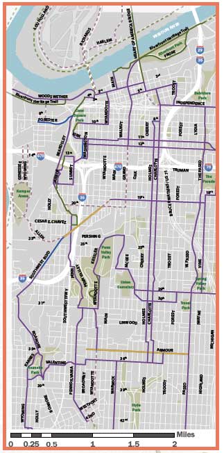
Looks impressive until you realize what purple represents.
-
earthling
- Mark Twain Tower
- Posts: 8519
- Joined: Sun Sep 11, 2011 2:27 pm
- Location: milky way, orion arm
Re: Bike Lanes
Yeah, signed routes need to become bike lanes. I bike midtown/downtown often and personally don't need them but apparently most prefer them and at least the signed paths give a biker a plan. Long way to go but you can't go from 0 to great in a short time. Going up 15 notches says KC is at least making the effort over comparable cities. STL didn't even make the list.
Are there tangible plans to convert some to actual bike lanes?
Edit: KC came in 33rd on bicycling.com, STL ranked 38th..
http://www.bicycling.com/news/advocacy/ ... as-city-mo
Are there tangible plans to convert some to actual bike lanes?
Edit: KC came in 33rd on bicycling.com, STL ranked 38th..
http://www.bicycling.com/news/advocacy/ ... as-city-mo
-
flyingember
- Mark Twain Tower
- Posts: 9862
- Joined: Tue Jul 17, 2012 7:54 am
Re: Bike Lanes
it's not even 100% accurate.
they have part of Pennslyvania as a marked bike lane
go down there and try to find the marked bike lane. the paint is 99% gone. a driver would have problems staying out of it
hopefully this is the start of better maintenance of the bike lanes.
because if they maintain the new ones as well as this one then they might as well not bother
-
earthling
- Mark Twain Tower
- Posts: 8519
- Joined: Sun Sep 11, 2011 2:27 pm
- Location: milky way, orion arm
Re: Bike Lanes
If you do a 'get directions' in Google Maps and select the bicycle icon, it shows pretty much the same map in the city and marks them as 'bike friendly roads' rather than 'dedicated lanes'. Although google shows using Main through downtown up to about 31st, which I agree is more daoble than through Midtown. I take it Main to Linwood and then cutover to Wyandotte through Midtown, which it also shows, but not the connection.
Maintenance of the markers is another issue.
Maintenance of the markers is another issue.
-
flyingember
- Mark Twain Tower
- Posts: 9862
- Joined: Tue Jul 17, 2012 7:54 am
Re: Bike Lanes
Google Maps can't do dedicated bike lanes yet. I know this for certain because I added a lot of what you see.
-
earthling
- Mark Twain Tower
- Posts: 8519
- Joined: Sun Sep 11, 2011 2:27 pm
- Location: milky way, orion arm
Re: Bike Lanes
It shows a few dedicated lanes in KC. San Fran and MSP maps show dedicated lanes.
-
dangerboy

- Global Moderator

- Posts: 9029
- Joined: Wed Feb 19, 2003 8:28 am
- Location: West 39th St. - KCMO
Re: Bike Lanes
Google Maps uses dark green for trails, bright green for bike lanes, and dotted green for designated routes without special facilities.
Southwest Boulevard is emblematic of two big problems for bike lanes.
1. Doing bike lanes instead of sharrows east of Summit would have required removing curb-side parking. Businesses and neighbors along the road were not willing to give up parking at the curb. In order to fit bike lanes into existing urban streets, neighborhoods have to be willing to give up parking and/or car lanes. The inability to flip the angle parking on Baltimore is a good example of an instance where a neighborhood wants better bike facilities but is unable to reach consensus.
2. So far the city only adds bike lanes when a street is built, widened, or repaved. There have been almost no retrofits of existing built-out streets. Since the capital improvements budget is under funded, the city only repaves short segments of streets every year. Thus the short segments of bike lanes like Southwest Boulevard and NW Barry Road. Southwest Boulevard will have bike lanes from the brewery all the way to downtown Merriam, but it will be slow and incremental until cities or voters decide to increase budgets.
Fortunately there is progress. The City has a $700,000 federal grant to add retro fit 12 miles of bike lanes Downtown in the next two years, including Grand, 20th, West Pennway, and 18th all the way to Vine.
-
pash
- Bryant Building
- Posts: 3800
- Joined: Sun Feb 20, 2011 2:47 am
-
kboish
- Hotel President
- Posts: 3258
- Joined: Mon Nov 26, 2007 12:25 am
- Location: West Plaza
Re: Bike Lanes
This is encouraging to hear. Thanks for the info.dangerboy wrote:Fortunately there is progress. The City has a $700,000 federal grant to add retro fit 12 miles of bike lanes Downtown in the next two years, including Grand, 20th, West Pennway, and 18th all the way to Vine.
Everything in KC moves at a snails pace, but at least we're moving in the right direction I guess.
-
flyingember
- Mark Twain Tower
- Posts: 9862
- Joined: Tue Jul 17, 2012 7:54 am
Re: Bike Lanes
better slow and well organized than massive sprawl development that KC has the space to dokboish wrote:This is encouraging to hear. Thanks for the info.dangerboy wrote:Fortunately there is progress. The City has a $700,000 federal grant to add retro fit 12 miles of bike lanes Downtown in the next two years, including Grand, 20th, West Pennway, and 18th all the way to Vine.
Everything in KC moves at a snails pace, but at least we're moving in the right direction I guess.
-
KCMax

- Global Moderator
- Posts: 24051
- Joined: Wed Aug 04, 2004 3:31 pm
- Location: The basement of a Ross Dress for Less
- Contact:
Re: Bike Lanes
Editorial: New bike lanes, trails promote bicycling in KC
The addition of short-term rental bikes to downtown and the Crossroads in 2012 was a major step forward for the image of cycling in Kansas City. Get more people pedaling, even for short distances, and they’ll see how practical it can be as a way to get around.
Also, the city continues to stripe more miles of bike lanes, vivid reminders that cars and trucks aren’t the only ones allowed to use the roads. There’s more to come, too. The new city budget calls for resurfacing or renovating more than 100 miles of streets in the next year, and City Manager Troy Schulte says the city will add painted bike lanes to many of these roads.
More trails have been extended in various parts of the city, too, giving bicycles more off-road places to safely ride.
-
chaglang

- Bryant Building
- Posts: 4132
- Joined: Wed Jan 04, 2012 12:44 pm
Re: Bike Lanes
http://www.theatlanticcities.com/commut ... need/4717/The city’s map prioritizes rider comfort in its symbology. "We tried to make it real intuitive," says Wilkes, who has been refining the concept for several years now. Bike trails, separated cycle tracks, and what the city terms "quiet streets" – in peaceful, low-traffic neighborhoods – are marked in vivid green. "High comfort" roads are bright blue."Medium comfort" is marked in a darker blue. "Low comfort" is indicated by a cautionary yellow. And red signifies "extremely low comfort," as in, you probably don’t want to go there unless you are one of the rodeo-riding one percent. Directional arrows indicate hills and how steep they are.
The result is a map that shows at a glance where the riding is easy and where it’s more challenging. Because the colors are parallel to those used by traffic lights (with the addition of that peaceful-looking blue) they make a deep kind of sense to our eyes and brains.
The goal, says Wilkes, is to give people the information they need when they set out to ride without getting into the terminology that engineers use when they are designing bike lanes – Class I, Class II, buffered, separated, cycle track, and so forth – which is essentially meaningless to the layperson, but which forms the basis of color-coding on most urban bike maps.