Re: Jackson County Regional Rail Plan
Posted: Tue Nov 19, 2013 7:07 pm
For my edification, where does "the trench" generally begin on its east end?
Thanks. I was having trouble getting a sense on Google Maps of where below grade tracks began. Is it at least fair to say that adding track on the portion that isn't below grade would be easier than in the trench itself?pash wrote:The tracks are below grade until a bit east of Benton Blvd.
Understood. I've been working on a small thought experiment where the commuter line runs on the track from Independence but moves to street running at Truman Road.Eon Blue wrote:That all depends on the bridges you cross or go under. Bridge replacements or modifications get expensive quickly.
that would be the original "jim terry" plan. while truman road is a wasteland, the requirements for running FRA-compliant equipment down the street are much more significant than, say, streetcar or light rail. that plan also would have run those trains down cherry street to connect with union station (something the crossroads is definitely not excited about). does your plan stop at truman road? maybe we get rid of 670 and turn that into a below grade train station?smh wrote:Understood. I've been working on a small thought experiment where the commuter line runs on the track from Independence but moves to street running at Truman Road.Eon Blue wrote:That all depends on the bridges you cross or go under. Bridge replacements or modifications get expensive quickly.
My plan eventually gets to a newly two-way 12th Street (ideally) and runs through downtown. Not sure where it goes from there, either to the West Bottoms or somehow (as you mentioned the other day) to KCK. I'm enamored with the Portland "tram-train" if you will and I've been wondering whether it might be a solution to the 3rd/Grand vs. Union Station railroad issue.DaveKCMO wrote:that would be the original "jim terry" plan. while truman road is a wasteland, the requirements for running FRA-compliant equipment down the street are much more significant than, say, streetcar or light rail. that plan also would have run those trains down cherry street to connect with union station (something the crossroads is definitely not excited about). does your plan stop at truman road? maybe we get rid of 670 and turn that into a below grade train station?smh wrote:Understood. I've been working on a small thought experiment where the commuter line runs on the track from Independence but moves to street running at Truman Road.Eon Blue wrote:That all depends on the bridges you cross or go under. Bridge replacements or modifications get expensive quickly.
Good point. I wonder if the supposed changes that FRA (I think?) is considering to allow European train models would have any effect on this. I suppose we're still talking diesel though...DaveKCMO wrote:once you see a DMU in operation you won't want them on the streets of downtown, especially 12th. it's not awful, but just remember there's a diesel engine in there and they are heftier looking than light rail (but smaller than traditional locomotive/coach).
this was covered earlier in this thread or the streetcar one. sounds like that's a different change than allowing lighter weight trains.smh wrote:Good point. I wonder if the supposed changes that FRA (I think?) is considering to allow European train models would have any effect on this. I suppose we're still talking diesel though...DaveKCMO wrote:once you see a DMU in operation you won't want them on the streets of downtown, especially 12th. it's not awful, but just remember there's a diesel engine in there and they are heftier looking than light rail (but smaller than traditional locomotive/coach).
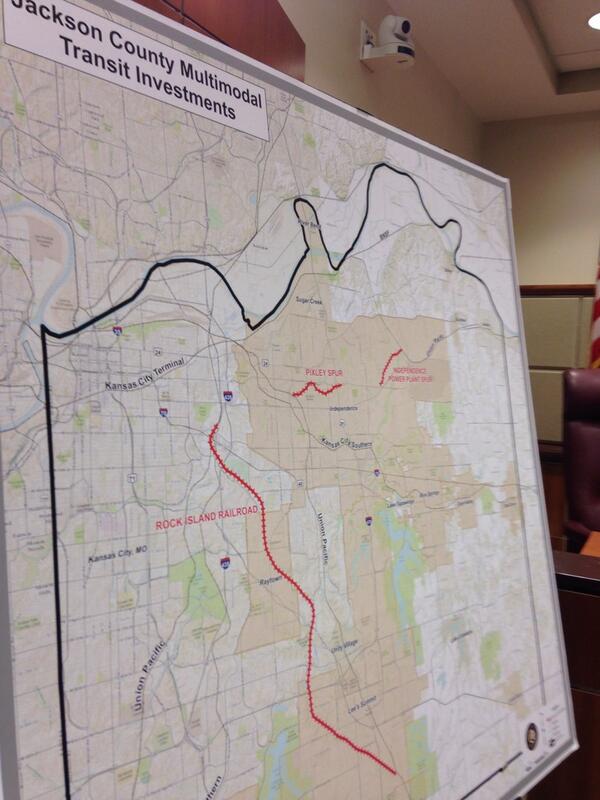
County Executive Mike Sanders will make an announcement today during the legislative meeting in regards to the potential acquisition of key transit corridors in Jackson County. Stay tuned for more this afternoon!
The terms of the agreement would allow the county to buy two pieces of un-used rail corridor totaling 19 miles. The biggest chunk, at 15.5 miles, is the former Rock Island Line trackage between Lee’s Summit and near the Truman Sports Complex.
In addition to being a possible route for commuter rail service, the corridor has long been seen the key connector to link Kansas City with the Katy Trail, the cross-state hiking and biking trail.
The other 3.5 miles is known as the Pixley Spur and extends eastward from near the Amtrak station in Independence.
Read more here: http://www.kansascity.com/2014/02/24/48 ... rylink=cpy

I believe you mean KCT (Kansas City Terminal) not KCS, and no--this segment stops short of that area.missingkc wrote:Does this agreement circumvent KCS' problems with the commuter traffic passing through the junction close to Winner and 485? Does it mean that the trench might be an option?