
Kansas City Metro Map I made
Kansas City Metro Map I made
I made this map to show how the streetcar/MAX/connex/& commuter rails lines would look together as a subway/metro style map, I thought it turned out pretty cool.
-
flyingember
- Mark Twain Tower

- Posts: 9862
- Joined: Tue Jul 17, 2012 7:54 am
Re: Kansas City Metro Map I made
Where did the rail line to Liberty come from?
Re: Kansas City Metro Map I made
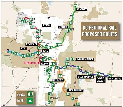
I pulled it off of this map. I have no idea if they are still considering it.flyingember wrote:Where did the rail line to Liberty come from?
Re: Kansas City Metro Map I made
I like it!
-
flyingember
- Mark Twain Tower
- Posts: 9862
- Joined: Tue Jul 17, 2012 7:54 am
Re: Kansas City Metro Map I made
I don't believe that's anywhere near on the table in the northland.
I wouldn't expect the northland to jump on board to this system until there's something running south of the river and I would give any amount of money that an airport connection will come well before one to Liberty, it's an easier sell for an election. (the stadium connection will help, just not a ton) The eventual northland commuter rail won't be a V but a triangle with a leg along 152 or 435. remember, one of the most congested segments of roads in the city is Shoal Creek Parkway to MO 291 and an alternative to adding more lanes from I-29 to I-35 could do well if it's comprehensive enough. they're talking about widening the bridge over I-35 but it won't take more than 5-7 years to be back to congestion even if it's done.
I personaly like the idea on improving bus up N. Oak and Antioch with the goal of putting a train in down the line. Houston is looking at a few BRT lines that will be track ready, I think KC should look at that.
How about we coordinate other projects? every single mile of utility will need replacing eventually, let's start coordinating this into planning down the line for the train on more corridors.
Then instead of planning one project at a time on the major transit corridors, start working together and come up with plans.
take it from Google Fiber, they wanted to work with a city that could cut red tape, do things efficinently and cost effective. The water department can make a 100-year replacement plan. Why can't we look 30-40 years out on laying track and do all planning with it in mind? We have to start somewhere. Cut the red tape for the telcos in these corridors to make things happen.
so when any sort of work is going to be done on these future streetcar segments it's all done and the street is made track ready. Why not start this with phase 2 in 2016? Instead of waiting for the feds to come through with money, begin to prep down each streetcar route. Nothing says shovel ready and wanting to build like prepping the line anyways. People want new sewers, let's give it to them. We need to do the work anyways.
could do similar along commuter corridors. it takes years to get train companies to make agreements. let's start today and get the capacity needs built into their construction.
Re: Kansas City Metro Map I made
I don't know if a rail line to the airport is a must at first. Denver got the core of their light rail system built out before expanding to the airport and even NYC doesn't have rail to LGA airport. Last time I was in NYC I took the M60 bus from the airport to the subway, its one of the few bus routes they put on their subway map, it was easy but it was slow...flyingember wrote:I don't believe that's anywhere near on the table in the northland.
I wouldn't expect the northland to jump on board to this system until there's something running south of the river and I would give any amount of money that an airport connection will come well before one to Liberty, it's an easier sell for an election. (the stadium connection will help, just not a ton) The eventual northland commuter rail won't be a V but a triangle with a leg along 152 or 435. remember, one of the most congested segments of roads in the city is Shoal Creek Parkway to MO 291 and an alternative to adding more lanes from I-29 to I-35 could do well if it's comprehensive enough. they're talking about widening the bridge over I-35 but it won't take more than 5-7 years to be back to congestion even if it's done.
I personaly like the idea on improving bus up N. Oak and Antioch with the goal of putting a train in down the line. Houston is looking at a few BRT lines that will be track ready, I think KC should look at that.
How about we coordinate other projects? every single mile of utility will need replacing eventually, let's start coordinating this into planning down the line for the train on more corridors.
Then instead of planning one project at a time on the major transit corridors, start working together and come up with plans.
take it from Google Fiber, they wanted to work with a city that could cut red tape, do things efficinently and cost effective. The water department can make a 100-year replacement plan. Why can't we look 30-40 years out on laying track and do all planning with it in mind? We have to start somewhere. Cut the red tape for the telcos in these corridors to make things happen.
so when any sort of work is going to be done on these future streetcar segments it's all done and the street is made track ready. Why not start this with phase 2 in 2016? Instead of waiting for the feds to come through with money, begin to prep down each streetcar route. Nothing says shovel ready and wanting to build like prepping the line anyways. People want new sewers, let's give it to them. We need to do the work anyways.
could do similar along commuter corridors. it takes years to get train companies to make agreements. let's start today and get the capacity needs built into their construction.
I think for rail to work to the airport, it needs to attract riders from JOCO so you'd need a line that goes down I-35 as well. I've taken the 129 bus to the airport several times and it never has any other fliers on it so I'm not sure if KCATA needs to do a better job of advertising they actually go to the airport or if middle/upper class people would rather pay the high parking/taxi prices over bus.
I would like to see a long term streetcar/commuter plan as well, it would probably start affecting future development and developers could plan their future projects knowing that they will eventually get a rail connection so density could actually start to go up along the rail corridors before the lines are even built.
-
flyingember
- Mark Twain Tower
- Posts: 9862
- Joined: Tue Jul 17, 2012 7:54 am
Re: Kansas City Metro Map I made
I'm not saying an airport line is a functional must.
I'm saying it will one of the first segments for the northland because it's something that will get votes for any rail plan. even streetcar will be a hard sell county-wide without the big impact airport connection in the list.
you can say the same of the stadiums south of the river. all but necessary at the ballot box to get what really matters.
I went looking and while it's true big cities generally don't have an airport connection early on, other medium sized cities do.
Minneapolis' original line is stadiums, airport, major tourist attraction. the second (opens soon) and third segments are much more about jobs than the first one.
it's the classic chicken-egg. most people want to know they can get someplace worth riding the train as a starting point. expansion is an easier sell because you can already get someplace
-
earthling
- Mark Twain Tower
- Posts: 8519
- Joined: Sun Sep 11, 2011 2:27 pm
- Location: milky way, orion arm
Re: Kansas City Metro Map I made
Here's a city guide I did a while back centered on Orange MAX line. Needs an update...

Re: Kansas City Metro Map I made
Speaking of maps, this is a reminder to myself to update the existing MAX Wikipedia article to use its standard transit map infoboxes and route information formatting (this is a good example of what it could look like).