one thing you might notice is maps show it connecting to Pleasant Hill.
this corridor is 17 miles and it ends ~10 miles from Pleasant Hill.
so there's one more segment to figure out for a cross state Katy Trail
Jackson County Regional Rail Plan
-
flyingember
- Mark Twain Tower

- Posts: 9862
- Joined: Tue Jul 17, 2012 7:54 am
-
flyingember
- Mark Twain Tower
- Posts: 9862
- Joined: Tue Jul 17, 2012 7:54 am
Re: Jackson County Regional Rail Plan
http://www.examiner.net/article/20151001/NEWS/151009969
this is the best article on the subject. the rest just basically copy the press release.
this is the best article on the subject. the rest just basically copy the press release.
-
longviewmo
- Alameda Tower
- Posts: 1008
- Joined: Sat Jun 20, 2009 12:58 am
- Location: Manhattan, Kansas
- Contact:
Re: Jackson County Regional Rail Plan
http://www.marc2.org/tr-call/UploadedFi ... ectMap.pdfflyingember wrote:one thing you might notice is maps show it connecting to Pleasant Hill.
this corridor is 17 miles and it ends ~10 miles from Pleasant Hill.
so there's one more segment to figure out for a cross state Katy Trail
-
flyingember
- Mark Twain Tower
- Posts: 9862
- Joined: Tue Jul 17, 2012 7:54 am
Re: Jackson County Regional Rail Plan
that map was part of the submission for the 2014 MARC STP money
http://www.marc2.org/tr-call/projectdet ... px?PID=561
they asked for $18 million
their $10 million in federal funding appears to be from that request, it's on these minutes
http://www.marc.org/Transportation/Comm ... 29-14.aspx
so basically they funded the yellow segment only. so that's will be the last 5 miles of the initial KC segment to fund. Then we can work on connecting it into downtown somehow.
and that's the best map yes. 5 miles to go.
-
bhedges1987
- Pad site
- Posts: 70
- Joined: Wed Apr 22, 2015 1:00 am
Re: Jackson County Regional Rail Plan
I don't understand? Their goal is to bring people to work. How many people work at arrowhead???
ALso, I don't see a map? Where in Lee's Summit will this start? Will it go down 470 to 70 and west to the stadiums?
ALso, I don't see a map? Where in Lee's Summit will this start? Will it go down 470 to 70 and west to the stadiums?
-
flyingember
- Mark Twain Tower
- Posts: 9862
- Joined: Tue Jul 17, 2012 7:54 am
Re: Jackson County Regional Rail Plan
For a map look at the two posts above yours.

Re: Jackson County Regional Rail Plan
KCATA and jackson county expect to close on the purchase of the rock island line in the first half of 2016.
Re: Jackson County Regional Rail Plan
http://www.examiner.net/article/20160405/NEWS/160409599
The County Legislature on Monday approved $52 million in bonds to buy 17.7 miles of tracks from the Union Pacific Railroad. The old Rock Island tracks, unused for 35 years, run from near Arrowhead and Kauffman stadiums southeast through Raytown to the Longview area of Lee’s Summit.
The bonds, at an average interest rate of 3.75 percent, are to paid off over 30 years at $2.875 million annually – half by the county and half by the ATA.
Re: Jackson County Regional Rail Plan
contracts for the rock island purchase will be signed may 2. at that point, KCATA will own TWO railroad lines!
Re: Jackson County Regional Rail Plan
official signing ceremony may 2. trail may open in 2018.
http://www.kansascity.com/news/politics ... 26187.html
http://www.kansascity.com/news/politics ... 26187.html
-
TheBigChuckbowski
- Bryant Building
- Posts: 3565
- Joined: Mon Nov 13, 2006 1:36 pm
- Location: Longfellow
Re: Jackson County Regional Rail Plan
How soon will we see this connect to a Blue River Trail and Brush Creek?
Re: Jackson County Regional Rail Plan
correction: KCATA will only own one railroad line. jackson county will have sole ownership of the rock island, although KCATA is footing half the bill for acquisition.DaveKCMO wrote:contracts for the rock island purchase will be signed may 2. at that point, KCATA will own TWO railroad lines!
Re: Jackson County Regional Rail Plan
It looks like it terminates fairly close (though across the Blue "river") to the northern end of the Brush Creek trail.TheBigChuckbowski wrote:How soon will we see this connect to a Blue River Trail and Brush Creek?
Re: Jackson County Regional Rail Plan
the tentative plan is to keep the old rock island rails intact as much as possible, so people don't forget it's a transit corridor in addition to a trail.
-
mykn
Re: Jackson County Regional Rail Plan
Good, I'd be worried it would become too much of a trail (Trolly Trail) and you would have a HUGE effort to get people ok with rail use.DaveKCMO wrote:the tentative plan is to keep the old rock island rails intact as much as possible, so people don't forget it's a transit corridor in addition to a trail.
Re: Jackson County Regional Rail Plan
contract to be awarded soon for trail construction. pretty sure not all of it can be built for the money they have, so it may happen in phases.
Re: Jackson County Regional Rail Plan
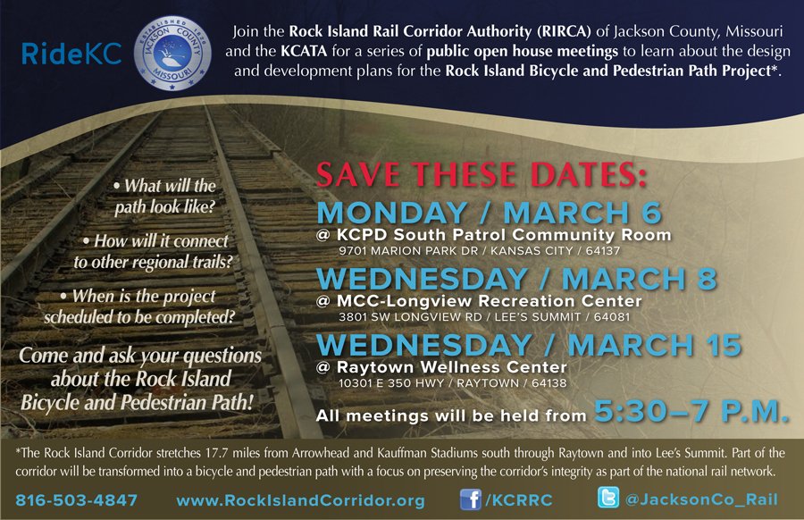
public meetings next month:
Re: Jackson County Regional Rail Plan
first meeting monday.DaveKCMO wrote:public meetings next month:
Re: Jackson County Regional Rail Plan
Went to the meeting. Pretty disappointed that they haven't settled on a plan to connect the Rock Island line to downtown or Pleasant hill. Currently if you are coming from St.Louis you would get to Pleasant Hill, get off on Smart Road (gravel) ride up to MO 150, take that through Greenwood all the way to Ward Rd. in Lee's Summit and up Ward to the trail head. The "Island" part of Rock Island Trail is pretty apropos.
Ward and 150 through LS have wide sidewalks meant for bikes, but from east of 291 to Smart road it's a two lane highway with no shoulders.
At the other end it terminates around 23rd street, at a Mobile Home park in an industrial district.
Who is going to use this? Eventual it will connect to the Little Blue Valley trail which you could take up to Independence or down to Grandview.
I know they are doing the best with what they have, but the meeting was pretty deflating.
Side note, just to pile on. Horrible job with the venue and planning for the open house. This was the Longview meeting.