I slept through the whole damn thing... had no idea any storms rolled through at all after the round that went through around 8:30-9:00. I had no idea what people were talking about this morning when I heard about destroyed homes and such until I started coming across fallen trees.
I did have a nightmare about a huge black tornado that went through downtown and destroyed half of the towers though.
The Official Kansas City Weather Thread
Re: The Official Kansas City Weather Thread
I live in Baja Gladstone. Century and a half old oak tree went down 2 doors up, and lots of Bradford Pears and Purple Leaf plums down. Some shingles blown off and saw some siding peeled off. During the worst of it one of my windows started leaking, it was like the house was in a combo wind tunnel/car wash.
Re: The Official Kansas City Weather Thread
Are you sleeping with the TV on again?scooterj wrote: I slept through the whole damn thing... had no idea any storms rolled through at all after the round that went through around 8:30-9:00. I had no idea what people were talking about this morning when I heard about destroyed homes and such until I started coming across fallen trees.
I did have a nightmare about a huge black tornado that went through downtown and destroyed half of the towers though.
If you're not on the EDGE, you're taking up TOO MUCH ROOM!

Re: The Official Kansas City Weather Thread
gladstone and k.c. are in the northland. gladstone is a puny 9.5 square miles around.AllThingsKC wrote: I wondering if The Star had made a mistake or if it really was Gladstone and the Northland.
Why is corporate welfare better than public socialism?
Veritas Nihilum Vincet.
Veritas Nihilum Vincet.
-
alpha_glamourina
- New York Life

- Posts: 465
- Joined: Wed Dec 13, 2006 9:46 pm
- Location: Somewhere Over the Rainbow
Re: The Official Kansas City Weather Thread
My husband and I slept through the second storm too. which is kind of odd because I tend to be a light sleeper. Hmm. My in-laws live north of the river, but are on vacation and they called around 8am to ask if we knew anything about how bad the damage was near- or God forbid, at- their home. Scarey. I was on my way out the door when they called and didn't get back til about an hour ago. Hopefully we won't see anything bad when we check on their house in about an hour.scooterj wrote: I slept through the whole damn thing... had no idea any storms rolled through at all after the round that went through around 8:30-9:00. I had no idea what people were talking about this morning when I heard about destroyed homes and such until I started coming across fallen trees.
I did have a nightmare about a huge black tornado that went through downtown and destroyed half of the towers though.
Moderne- how is your leaky window? Was it just a weather fluke, or did it suffer serious damage from the onslaught?
Jess- not that the flying port-a-potty was funny at the time, but...it sure is a funny thing to image right now after the danger has passed! That must have been one of the most surreal experiences of your life, right?!
-
heatherkay
- Alameda Tower
- Posts: 1424
- Joined: Tue Feb 14, 2006 10:39 am
- Location: River Market and Rosedale
Re: The Official Kansas City Weather Thread
We had something similar here in Rosedale. My front door faces west, but under a 7 foot overhang. Right after the worst of the storm, we noticed a big puddle in front of the door.moderne wrote: During the worst of it one of my windows started leaking, it was like the house was in a combo wind tunnel/car wash.
Re: The Official Kansas City Weather Thread
Yeah tell the people in gladstone and Liberty that. This was certainly caused by straightline winds.shaffe wrote: but in all honesty the storm at 2am wasn't tornadic when it was going through kc,
KANSAS CITY, Mo. -- The National Weather Service said that two tornadoes touched down in the Northland early Friday morning.
The first tornado hit at about 2 a.m. in Gladstone and was classified as an EF 2, which means its winds were between 111 mph and 142 mph.
The second tornado touched down in the Brookridge area and was classified as an EF 3, which has winds between 142 mph and 162 mph.


-
Gladstoner

- Penntower
- Posts: 2036
- Joined: Thu Jan 06, 2005 6:38 pm
- Location: Far from the middle of nowhere
Re: The Official Kansas City Weather Thread
Isn't that what they call a 'split entry'?KCLover wrote:
A fool and your money are soon united.
-
AllThingsKC

- Mark Twain Tower
- Posts: 9365
- Joined: Tue Aug 17, 2004 10:57 am
- Location: Kansas City, Missouri (Downtown)
- Contact:
Re: The Official Kansas City Weather Thread
My mother and brother in Gladstone, very close to 77th & Euclid. Their house has minimal damage, but the house that's 2 houses away from them was completely destroyed.
They are still without power.
They are still without power.
KC is the way to be!
-
Jess

- Western Auto Lofts
- Posts: 662
- Joined: Mon Aug 27, 2007 5:28 pm
- Location: Lee's Summit, former Waldo/Plaza
Re: The Official Kansas City Weather Thread
Very surreal, and a bit funny, even at the time! The Washington Irving has old school, wavy glass windows, not tempered replacements, and I was a little afraid that we were gonna get showered with glass if debris was flying and hit the windows in our bedroom, so we migrated to the couch to doze until the high winds passed, safely away from said windows.alpha_glamourina wrote:
Jess- not that the flying port-a-potty was funny at the time, but...it sure is a funny thing to image right now after the danger has passed! That must have been one of the most surreal experiences of your life, right?!
Also, I went through an F-4/ F-5 cusp tornado back in the day that resulted in near total destruction of my community at the time, and the damage in the Northland def. looks tornadic, to me.
-
AllThingsKC
- Mark Twain Tower
- Posts: 9365
- Joined: Tue Aug 17, 2004 10:57 am
- Location: Kansas City, Missouri (Downtown)
- Contact:
Re: The Official Kansas City Weather Thread
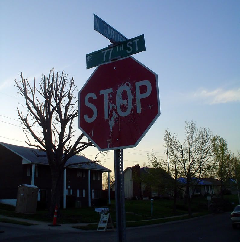
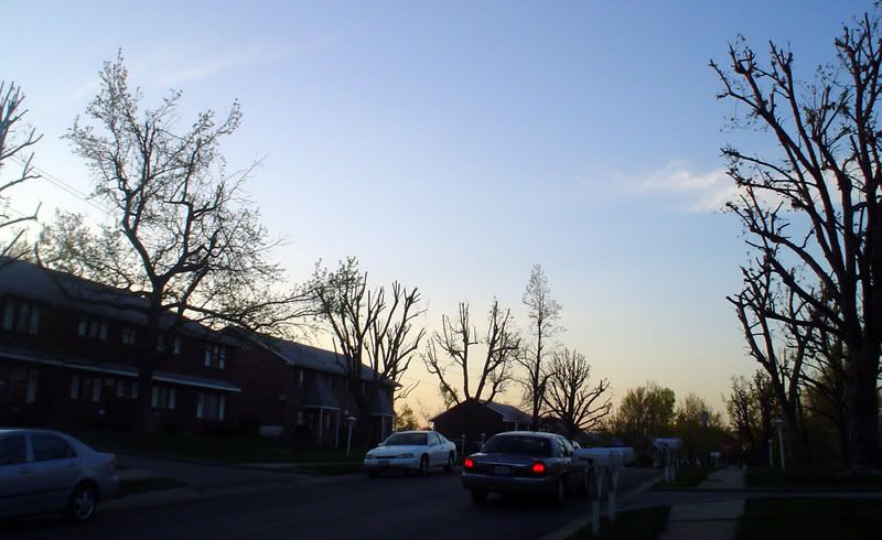
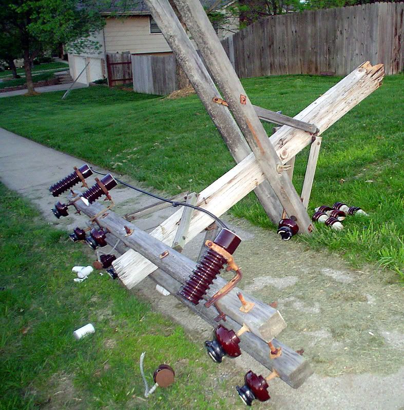
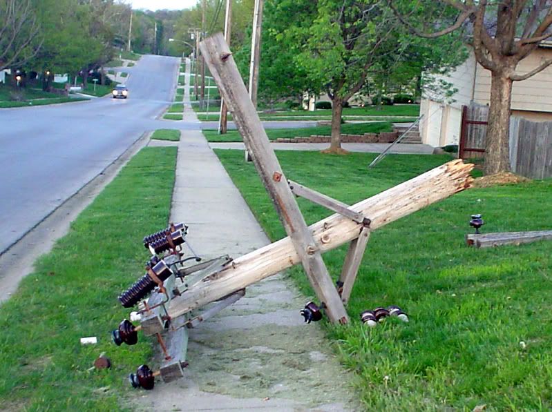
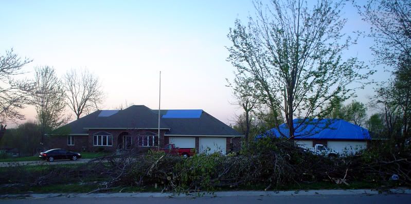
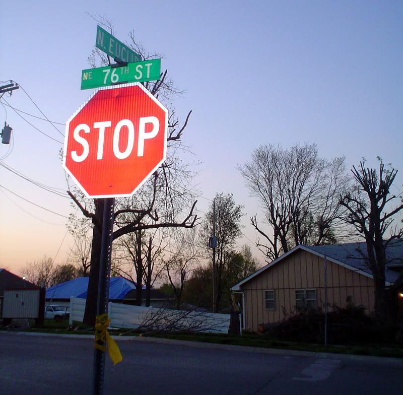
I took a tour of what's left of my mother's nieghboorhood in Gladstone today. North Euclid between 76th & 77th was completely blocked off by police cars. So, I was unable to get good photos from that area.
These photos don't show the same level of damage that KCLover's photos show. That's mainly because the clean-up was underway by the time I saw the area, and the block with the most damage was closed. These are photos from around N. Euclid:
These photos don't show the same level of damage that KCLover's photos show. That's mainly because the clean-up was underway by the time I saw the area, and the block with the most damage was closed. These are photos from around N. Euclid:
1.
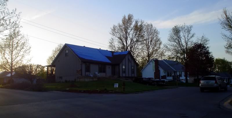
2.
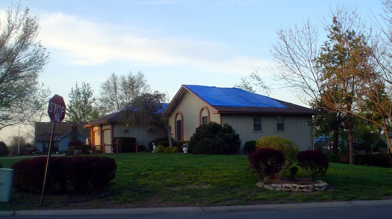
3.
4.
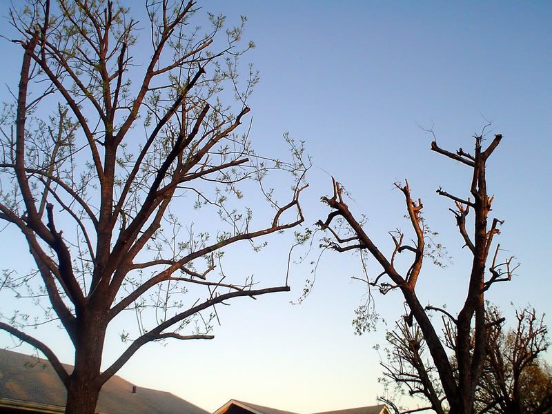
5. Notice the Trees:
6.
7.
8.
9. On the lawn from a house on N. Euclid (not sure what it means):
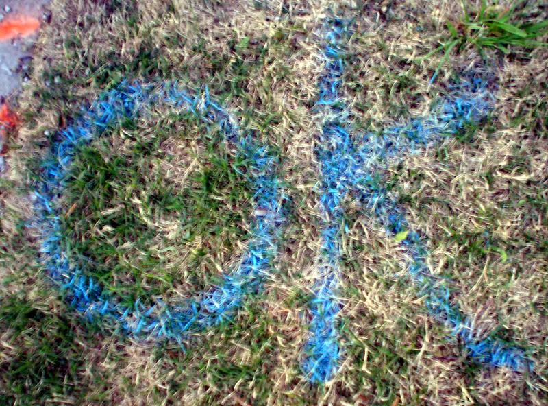
10.
2.
3.
4.
5. Notice the Trees:
6.
7.
8.
9. On the lawn from a house on N. Euclid (not sure what it means):
10.
KC is the way to be!
-
Gladstoner
- Penntower
- Posts: 2036
- Joined: Thu Jan 06, 2005 6:38 pm
- Location: Far from the middle of nowhere
Re: The Official Kansas City Weather Thread
Here's a radar loop of the storms passing through:
http://www.rap.ucar.edu/weather/radar/d ... duration=2
http://www.rap.ucar.edu/weather/radar/d ... duration=2
A fool and your money are soon united.
Re: The Official Kansas City Weather Thread
Correct me if I'm wrong, but isn't that area fairly near where the tornado hit a couple of years ago?
[img width=35 height=40]http://joanongovernment.homestead.com/f ... inging.gif[/img]

Re: The Official Kansas City Weather Thread
that area got hit then, but wasn't ground zero. Carriage hills to the NE took the brunt.nota wrote: Correct me if I'm wrong, but isn't that area fairly near where the tornado hit a couple of years ago?
-
drramos101
- Pad site
- Posts: 74
- Joined: Fri Dec 14, 2007 11:06 pm
- Location: Platte County
Re: The Official Kansas City Weather Thread
Anyone see the moon outside tonight? It looks pretty cool. there's like two rings around it. I might be easily amused, but I don't think I've ever seen it look like this. Didn't know where else to post this.
Re: The Official Kansas City Weather Thread
CRAZY RAIN tonight....i mean HEAVY Plaza and south....Brush Creek almost to top of banks on Plaza.
-
AllThingsKC
- Mark Twain Tower
- Posts: 9365
- Joined: Tue Aug 17, 2004 10:57 am
- Location: Kansas City, Missouri (Downtown)
- Contact:
Re: The Official Kansas City Weather Thread
There was quater-size hail downtown eailer today.
KC is the way to be!
-
Gladstoner
- Penntower
- Posts: 2036
- Joined: Thu Jan 06, 2005 6:38 pm
- Location: Far from the middle of nowhere
Re: The Official Kansas City Weather Thread
Wall cloud near Olathe and Lenexa:

Wall cloud in Lee's Summit:
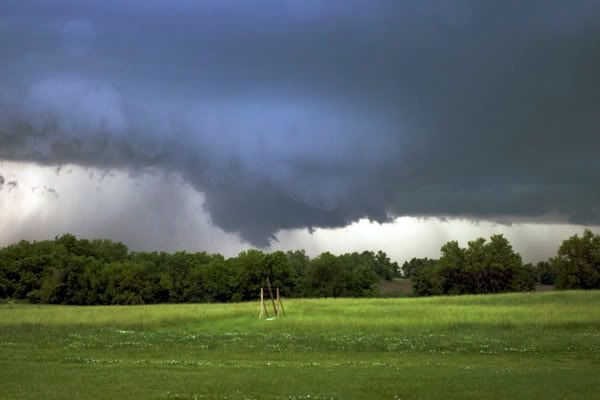
(taken by local storm chasers)
Wall cloud in Lee's Summit:
(taken by local storm chasers)
A fool and your money are soon united.
Re: The Official Kansas City Weather Thread
Where are the pictures?AllThingsKC wrote: There was quater-size hail downtown eailer today.
If you're not on the EDGE, you're taking up TOO MUCH ROOM!
Re: The Official Kansas City Weather Thread
The National Weather Service is giving advance warning of a possible tornado outbreak in the Great Plains on Thursday with conditions similar to a deadly day in 1974 when 39 tornadoes touched down.
Computer forecasting models for Thursday resemble those on June 8, 1974, when more than three dozen tornadoes touched down in the southern Plains and killed 22 people, including six in Emporia.
“I think this event warrants more advance warning,” said Robb Lawson, a meteorologist with the National Weather Service in Wichita.
The National Oceanic and Atmospheric Administration’s Storm Prediction Center has been warning for days of the outbreak.
Some forecasters are predicting the tornadoes could hit a corridor stretching from northern Oklahoma to central Iowa, said Mike Smith, chief executive officer of WeatherData Inc., a subsidiary of AccuWeather.
“Certainly Wichita, Topeka, Emporia, Salina, Chanute ... essentially the eastern half of Kansas should really be paying attention on Thursday,” Smith said.
Smith said temperature and humidity patterns for Thursday are similar to the 1974 outbreak, with a wave of energy in the upper atmosphere projected to be in exactly the same position.
With so much humidity in place, storms on Thursday could form and quickly become strong, forecasters said.

This looks like a bad severe weather outbreak, folks! Thursday afternoon and night we're expecting numerous reports of hail, high winds and tornadoes across a large portion of the Central states. This is the type of situation that can breed the extremely powerful EF4 and EF5 tornadoes, although storms of such severity are not that common. Even in the worst tornado outbreaks the number of extreme tornadoes makes up a small percentage of the total number of storms.
Certainly the most critical issue is where the storm hits. If an EF5 tornado travels across corn fields no big harm is done, but it's much different if the storm runs through a populated area.
Back to the situation at hand, it's a bad one capable of producing a significant amount of damage. More on this to follow.
Computer forecasting models for Thursday resemble those on June 8, 1974, when more than three dozen tornadoes touched down in the southern Plains and killed 22 people, including six in Emporia.
“I think this event warrants more advance warning,” said Robb Lawson, a meteorologist with the National Weather Service in Wichita.
The National Oceanic and Atmospheric Administration’s Storm Prediction Center has been warning for days of the outbreak.
Some forecasters are predicting the tornadoes could hit a corridor stretching from northern Oklahoma to central Iowa, said Mike Smith, chief executive officer of WeatherData Inc., a subsidiary of AccuWeather.
“Certainly Wichita, Topeka, Emporia, Salina, Chanute ... essentially the eastern half of Kansas should really be paying attention on Thursday,” Smith said.
Smith said temperature and humidity patterns for Thursday are similar to the 1974 outbreak, with a wave of energy in the upper atmosphere projected to be in exactly the same position.
With so much humidity in place, storms on Thursday could form and quickly become strong, forecasters said.
This looks like a bad severe weather outbreak, folks! Thursday afternoon and night we're expecting numerous reports of hail, high winds and tornadoes across a large portion of the Central states. This is the type of situation that can breed the extremely powerful EF4 and EF5 tornadoes, although storms of such severity are not that common. Even in the worst tornado outbreaks the number of extreme tornadoes makes up a small percentage of the total number of storms.
Certainly the most critical issue is where the storm hits. If an EF5 tornado travels across corn fields no big harm is done, but it's much different if the storm runs through a populated area.
Back to the situation at hand, it's a bad one capable of producing a significant amount of damage. More on this to follow.